1
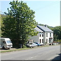
House near a bend in the A4043, Abersychan
The A4043 is a 10km long road from Blaenavon in the north to Pontypool in the south.
The A4043's route is along a river valley (the Afon Lwyd). The river here is 90 metres behind the house.
Image: © Jaggery
Taken: 29 Sep 2015
0.04 miles
2
A4043 Cwmavon Road
Image: © Colin Pyle
Taken: 17 Dec 2013
0.06 miles
3
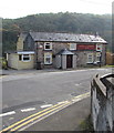
Twyn-y-Ffrwd Inn, Abersychan
Ffrwd Road pub viewed from the corner of Incline Road.
Image: © Jaggery
Taken: 29 Sep 2015
0.06 miles
4
Ffrwd Road houses, Abersychan
Tovry House is on the right.
Image: © Jaggery
Taken: 29 Sep 2015
0.07 miles
5
End of the Ffrwd Road one-way system, Abersychan
Alongside the Twyn-y-Ffrwd Inn http://www.geograph.org.uk/photo/4679934 the triangular sign showing
two black arrows marks the start of two-way traffic on Ffrwd Road.
Image: © Jaggery
Taken: 29 Sep 2015
0.08 miles
6
Road ascending from the A4043 to Ffrwd Road, Abersychan
This is a shortcut for walkers but not for motor vehicles
because there are metal railings across the road behind the camera.
Image: © Jaggery
Taken: 29 Sep 2015
0.08 miles
7
Junction of Incline Road and Ffrwd Road, Abersychan
Incline Road on the left joins Ffrwd Road.
Image: © Jaggery
Taken: 29 Sep 2015
0.09 miles
8
Coed-yr-eos House, Abersychan
Located on the east side of Station Street (A4043).
Image: © Jaggery
Taken: 28 Apr 2011
0.09 miles
9
Twyn-y-ffrwd Inn, Abersychan
Located in northeast Abersychan, at the northern end of Ffrwd Road.
Image: © Jaggery
Taken: 12 May 2010
0.10 miles
10
Ffrwd Road, Abersychan
Houses near the northern end of Ffrwd Road.
The edge of Twyn-y-ffrwd Inn http://www.geograph.org.uk/photo/1858162 can be seen at the left of the houses.
Image: © Jaggery
Taken: 12 May 2010
0.10 miles


