IMAGES TAKEN NEAR TO
Ffrwd Road, PONTYPOOL, NP4 8PE
Introduction
This page details the photographs taken nearby to Ffrwd Road, NP4 8PE by members of the Geograph project.
The Geograph project started in 2005 with the aim of publishing, organising and preserving representative images for every square kilometre of Great Britain, Ireland and the Isle of Man.

There are currently over 7.5m images from over14,400 individuals and you can help contribute to the project by visiting https://www.geograph.org.uk
Image Map
Images are licensed for reuse under creativecommons.org/licenses/by-sa/2.0
Notes
- Clicking on the map will re-center to the selected point.
- The higher the marker number, the further away the image location is from the centre of the postcode.
Image Listing (204 Images Found)
Images are licensed for reuse under creativecommons.org/licenses/by-sa/2.0
Image
Details
Distance
1
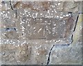
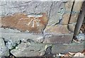
Ordnance Survey Cut Mark
This OS cut mark can be found at the entrance to Saas-Fee House. It marks a point 185.443m above mean sea level.
Image: © Adrian Dust
Taken: 25 Aug 2019
0.01 miles
2
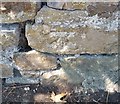
Ordnance Survey Cut Mark
This OS cut mark can be found on the wall west side of the road. It marks a point 188.461m above mean sea level.
Image: © Adrian Dust
Taken: 25 Aug 2019
0.05 miles
3
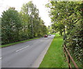
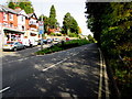
Pavementless part of the A4043 in Abersychan
The A4043 is a 10km long road from Blaenavon in the north to Pontypool in the south. The A4043's route is along a river valley (the Afon Lwyd). There are no pavements alongside this part of the road, only grass banks which are still wet at 10am after a heavy overnight dewfall in late September 2015.
Image: © Jaggery
Taken: 29 Sep 2015
0.05 miles
4
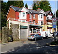
Petals Florists, Abersychan
Shop at the southern end of Ffrwd Road, viewed across the A4043.
Image: © Jaggery
Taken: 29 Sep 2015
0.07 miles
5
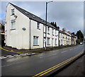
Ffrwd Road houses, Abersychan
Houses at the southern end of Ffrwd Road viewed across the A4043.
Image: © Jaggery
Taken: 12 Dec 2019
0.07 miles
6
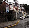
Junction of the A4043 and Ffrwd Road, Abersychan
Ffrwd Road on the left diverges from the A4043, the road north to Blaenavon along the valley of the Afon Lwyd. Petals Florists shop http://www.geograph.org.uk/photo/4678406 is on the left.
Image: © Jaggery
Taken: 29 Sep 2015
0.08 miles
7
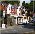
Signs at the southern end of Ffrwd Road, Abersychan
Viewed across the A4043. The signs show one-way street and no entry to motor vehicles except for access.
The grey car is parked in front of Petals Florists. http://www.geograph.org.uk/photo/4678406
Image: © Jaggery
Taken: 29 Sep 2015
0.09 miles
8
Ordnance Survey Cut Mark
This OS cut mark can be found on the wall SW side of Old Lane. It marks a point 193.252m above mean sea level.
Image: © Adrian Dust
Taken: 25 Aug 2019
0.09 miles
9

Junction of Ffrwd Road and the A4043, Abersychan
Ffrwd Road on the left diverges from the A4043, the road north to Blaenavon along the valley of the Afon Lwyd. Signs facing the A4043 show that Ffrwd Road is one way and no motor vehicles except for access.
Image: © Jaggery
Taken: 15 Mar 2018
0.09 miles
10
Station Street houses, Abersychan
Extending for 50 metres along the west side of the A4043 Station Street. The Old Lane junction is on the left.
Image: © Jaggery
Taken: 15 Mar 2018
0.10 miles