IMAGES TAKEN NEAR TO
George Street, PONTYPOOL, NP4 8NW
Introduction
This page details the photographs taken nearby to George Street, NP4 8NW by members of the Geograph project.
The Geograph project started in 2005 with the aim of publishing, organising and preserving representative images for every square kilometre of Great Britain, Ireland and the Isle of Man.

There are currently over 7.5m images from over14,400 individuals and you can help contribute to the project by visiting https://www.geograph.org.uk
Image Map
Images are licensed for reuse under creativecommons.org/licenses/by-sa/2.0
Notes
- Clicking on the map will re-center to the selected point.
- The higher the marker number, the further away the image location is from the centre of the postcode.
Image Listing (169 Images Found)
Images are licensed for reuse under creativecommons.org/licenses/by-sa/2.0
Image
Details
Distance
1
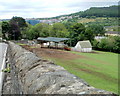
Ty-gwyn Farm, Pontnewynydd
Farm buildings viewed across the Hospital Road perimeter wall.
Image: © Jaggery
Taken: 9 May 2011
0.01 miles
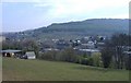
3
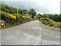
Hospital Road Pontnewynydd
Hospital Road descends from the junction http://www.geograph.org.uk/photo/2412304 with Leigh Road and Lower Leigh Road.
Image: © Jaggery
Taken: 9 May 2011
0.05 miles
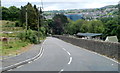
4
Potential hazard ahead for walkers on Hospital Road, Pontnewynydd
I obviously lived to tell the tale, but as a walker felt distinctly uncomfortable at the prospect ahead - no pavements and a double bend in the road. And there was no comfort in the name of the road - there is no hospital in the vicinity.
Image: © Jaggery
Taken: 9 May 2011
0.05 miles
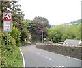
5
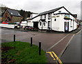
Royal Oak, Pontnewynydd
Pub alongside the B4246. Some maps show this location as the southern end of Freeholdland Road
whereas the pub's website states (the northern end of) George Street.
Image: © Jaggery
Taken: 17 Dec 2015
0.05 miles
6
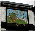
Royal Oak name sign, Pontnewynydd
On a corner of this http://www.geograph.org.uk/photo/4767230 pub. The faded gold lettering at the bottom of the sign formerly showed USHERS.
Image: © Jaggery
Taken: 17 Dec 2015
0.05 miles
7
Bus stop opposite the Royal Oak, Pontnewynydd
On the B4246 opposite this http://www.geograph.org.uk/photo/4767230 pub.
Image: © Jaggery
Taken: 17 Dec 2015
0.06 miles
8
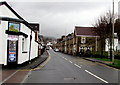
Leigh Road, Pontnewynydd
Lower Leigh Road behind the camera becomes Leigh Road ahead, on passing the right turn for Hospital Road.
Image: © Jaggery
Taken: 9 May 2011
0.06 miles
9
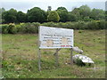
Abandoned housing development, Hospital Road, Pontnewynydd
A battered board announces a housing development on a triangle of land between Hospital Road and Leigh Road. Presumably the development was a victim of the credit crunch. The site is mostly weeds, and some pipes. http://www.geograph.org.uk/photo/2412335
Image: © Jaggery
Taken: 9 May 2011
0.06 miles
10
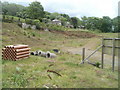
Pipes on an abandoned housing development site, Hospital Road, Pontnewynydd
A battered sign http://www.geograph.org.uk/photo/2412331 and some pipes are all that remain of an abandoned housing development project on a triangle of land between Hospital Road and Leigh Road.
Image: © Jaggery
Taken: 9 May 2011
0.06 miles