IMAGES TAKEN NEAR TO
Penygarn Road, PONTYPOOL, NP4 8BQ
Introduction
This page details the photographs taken nearby to Penygarn Road, NP4 8BQ by members of the Geograph project.
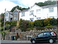
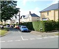
The Geograph project started in 2005 with the aim of publishing, organising and preserving representative images for every square kilometre of Great Britain, Ireland and the Isle of Man.

There are currently over 7.5m images from over14,400 individuals and you can help contribute to the project by visiting https://www.geograph.org.uk
Image Map
Images are licensed for reuse under creativecommons.org/licenses/by-sa/2.0
Notes
- Clicking on the map will re-center to the selected point.
- The higher the marker number, the further away the image location is from the centre of the postcode.
Image Listing (161 Images Found)
Images are licensed for reuse under creativecommons.org/licenses/by-sa/2.0
Image
Details
Distance
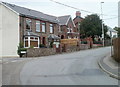
1
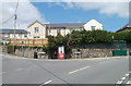
Corner of Penygarn Road and Channel View, Pontypool
Penygarn Road is on the left side of the phonebox and postbox. Channel View passes the bus shelter on the right.
Image: © Jaggery
Taken: 27 May 2011
0.01 miles
2
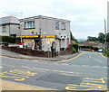
Penygarn Stores, Pontypool
Located on the corner of Channel View and St David's Close.
Now a Premier store, the shop was formerly a Mace store with Penygarn sub post office inside. The post office closed in 2008.
Image: © Jaggery
Taken: 1 Jun 2011
0.05 miles
3
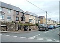
Western end of College Road, Penygarn, Pontypool
Viewed from Penygarn Road.
Image: © Jaggery
Taken: 1 Jun 2011
0.06 miles
4
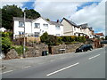
Penygarn Road houses at the Churchwood Close junction, Pontypool
Image: © Jaggery
Taken: 27 May 2011
0.08 miles
5
Churchwood Close, Pontypool
Houses at the eastern end of the close, viewed from Penygarn Road.
Image: © Jaggery
Taken: 27 May 2011
0.08 miles
6
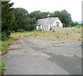
Site of demolished Trevethin Community School, Pontypool
One derelict building remains on the site of the demolished school on the west side of Penygarn Road.
The school closed in 2007 despite local protests which included hundreds of people marching through Pontypool town centre, and the lobbying of Torfaen County Borough Council and National Assembly for Wales in Cardiff.
Image: © Jaggery
Taken: 1 Jun 2011
0.09 miles
7
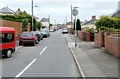
James Street, Penygarn, Pontypool
The view east from the corner of Penygarn Road.
Image: © Jaggery
Taken: 1 Jun 2011
0.09 miles
8
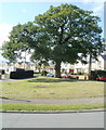
Oak tree dominates eastern end of College Road, Penygarn, Pontypool
Photographed across Channel View.
Image: © Jaggery
Taken: 20 May 2011
0.12 miles
9
Eastern end of College Road, Penygarn, Pontypool
From Channel View, looking past the edge of a towering oak. http://www.geograph.org.uk/photo/2429806
Image: © Jaggery
Taken: 20 May 2011
0.12 miles
10
Houses between the two arms of Old Penygarn, Pontypool
The turning on the left leads to a road following an elongated horseshoe course through Old Penygarn. The houses, on Penygarn Road, occupy the 30 metre long space between the two ends of the horseshoe.
Image: © Jaggery
Taken: 1 Jun 2011
0.13 miles