IMAGES TAKEN NEAR TO
Greenfield Terrace, PONTYPOOL, NP4 7TZ
Introduction
This page details the photographs taken nearby to Greenfield Terrace, NP4 7TZ by members of the Geograph project.
The Geograph project started in 2005 with the aim of publishing, organising and preserving representative images for every square kilometre of Great Britain, Ireland and the Isle of Man.

There are currently over 7.5m images from over14,400 individuals and you can help contribute to the project by visiting https://www.geograph.org.uk
Image Map
Images are licensed for reuse under creativecommons.org/licenses/by-sa/2.0
Notes
- Clicking on the map will re-center to the selected point.
- The higher the marker number, the further away the image location is from the centre of the postcode.
Image Listing (77 Images Found)
Images are licensed for reuse under creativecommons.org/licenses/by-sa/2.0
Image
Details
Distance
1
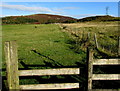
Public footpath, Varteg
Accessed via a stile http://www.geograph.org.uk/photo/4673857 50 metres west of Varteg Road, the public footpath is a track along the edge of a fence.
Image: © Jaggery
Taken: 25 Sep 2015
0.11 miles
2
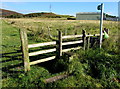
Stile to a public footpath, Varteg
50 metres west of Varteg Road, the stile gives walkers access to this http://www.geograph.org.uk/photo/4673852 track.
Image: © Jaggery
Taken: 25 Sep 2015
0.12 miles
3
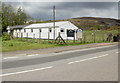
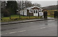
Sardis chapel, Varteg
Congregational chapel located on the west side of the B4246.
Image: © Jaggery
Taken: 12 May 2010
0.12 miles
4
Sardis Congregational Chapel, Varteg
Located on Varteg Road (B4246). A small extension has been added to the front of the chapel since this view http://www.geograph.org.uk/photo/1856950 taken the previous year.
Image: © Jaggery
Taken: 14 Jul 2011
0.12 miles
5
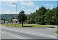
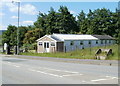
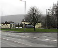
Bus terminus and turning circle, Varteg
Located on the west side of the B4246, immediately south of Sardis Chapel. http://www.geograph.org.uk/photo/2505783
It is the terminus for Stagecoach service 23 from Newport.
Image: © Jaggery
Taken: 14 Jul 2011
0.12 miles
6
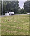
White coach, Varteg, Torfaen
Anslow Coaches coach parked at the edge of Varteg Terminus in June 2022.
Image: © Jaggery
Taken: 28 Jun 2022
0.13 miles
7
Secular use for Sardis Chapel in Varteg on December 12th 2019
The chapel is in use as a polling station today for voting in the UK General
Election - the first UK General Election to be held in December since 1923.
Image: © Jaggery
Taken: 12 Dec 2019
0.14 miles
8
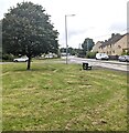
Tree on grass, Varteg, Torfaen
The B4246 Varteg Road is on the right.
Image: © Jaggery
Taken: 28 Jun 2022
0.14 miles
9
Varteg Terminus
Bus stop on the west side of the B4246 Varteg Road.
Image: © Jaggery
Taken: 12 Dec 2019
0.14 miles
10
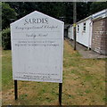
Sardis Congregational Chapel information board, Varteg
Facing Varteg Road outside this https://www.geograph.org.uk/photo/2505783 chapel.
Image: © Jaggery
Taken: 16 Jul 2018
0.14 miles