IMAGES TAKEN NEAR TO
Abersychan, PONTYPOOL, NP4 7TU
Introduction
This page details the photographs taken nearby to NP4 7TU by members of the Geograph project.
The Geograph project started in 2005 with the aim of publishing, organising and preserving representative images for every square kilometre of Great Britain, Ireland and the Isle of Man.

There are currently over 7.5m images from over14,400 individuals and you can help contribute to the project by visiting https://www.geograph.org.uk
Image Map
Images are licensed for reuse under creativecommons.org/licenses/by-sa/2.0
Notes
- Clicking on the map will re-center to the selected point.
- The higher the marker number, the further away the image location is from the centre of the postcode.
Image Listing (116 Images Found)
Images are licensed for reuse under creativecommons.org/licenses/by-sa/2.0
Image
Details
Distance
1
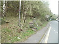
Steps from Foundry Road into a wood, Abersychan
Opposite the eastern edge of Cleaves Terrace, http://www.geograph.org.uk/photo/2360254 steps lead to a path into a wood.
Image: © Jaggery
Taken: 16 Apr 2011
0.03 miles
2
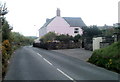
Pink house, Pentwyn Road, Abersychan
Located near the western end of Pentwyn Road.
Image: © Jaggery
Taken: 16 Apr 2011
0.04 miles
3
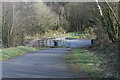
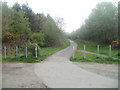
Cycle route 492 at Pentwyn Road
The cycleway goes down through the squeeze stile to cross the end of Pentwyn Road and continues to the right on a former railway line Image
Image: © M J Roscoe
Taken: 25 Feb 2022
0.05 miles
4
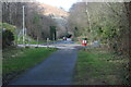
Junction of cycle route with Pentwyn Road & The Promenade
NCR 492 goes up to the left off Pentwyn Road, out of shot Image The Promenade is on the route of a former mineral line which went through the historic 'Big Arch' at the end of the road to the British Iron Works.
Image: © M J Roscoe
Taken: 25 Feb 2022
0.05 miles
5

Cleaves Terrace, Foundry Road, Abersychan
Cleaves Terrace is a row of 18 houses on the north side of Foundry Road (B4246).
The houses face the edge of a wood http://www.geograph.org.uk/photo/2360264 on the south side of Foundry Road.
Image: © Jaggery
Taken: 16 Apr 2011
0.06 miles
6

Foundry Road telephone exchange, Abersychan
British Telecom premises located near the western edge of Cleaves Terrace. http://www.geograph.org.uk/photo/2360254
Image: © Jaggery
Taken: 16 Apr 2011
0.06 miles
7
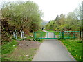
Barrier across a path, Pentwyn, Abersychan
The barrier is intended to prevent misuse of the path and cycle route by motor vehicles.
Walkers and cyclists can bypass the barrier via the side route on the left.
Image: © Jaggery
Taken: 16 Apr 2011
0.06 miles
8
Cycle route, Pentwyn, Abersychan
Viewed from the SE end of The Promenade. National Cycle Network route 492 heads towards the village of Pentwyn.
Image: © Jaggery
Taken: 16 Apr 2011
0.06 miles
9
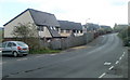
Pentwyn Heights, Abersychan
Modern housing viewed from Pentwyn Road.
Image: © Jaggery
Taken: 16 Apr 2011
0.06 miles
10
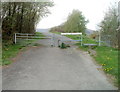
Barrier on NCR route 46 near Pentwyn
National Cycle Network route 46 here uses the trackbed of a dismantled railway.
The sign at the barrier states NO MOTOR VEHICLES EXCEPT DISABLED CARRIAGES.
Image: © Jaggery
Taken: 16 Apr 2011
0.08 miles