IMAGES TAKEN NEAR TO
Rhiw Franc Place, PONTYPOOL, NP4 7TR
Introduction
This page details the photographs taken nearby to Rhiw Franc Place, NP4 7TR by members of the Geograph project.
The Geograph project started in 2005 with the aim of publishing, organising and preserving representative images for every square kilometre of Great Britain, Ireland and the Isle of Man.

There are currently over 7.5m images from over14,400 individuals and you can help contribute to the project by visiting https://www.geograph.org.uk
Image Map
Images are licensed for reuse under creativecommons.org/licenses/by-sa/2.0
Notes
- Clicking on the map will re-center to the selected point.
- The higher the marker number, the further away the image location is from the centre of the postcode.
Image Listing (107 Images Found)
Images are licensed for reuse under creativecommons.org/licenses/by-sa/2.0
Image
Details
Distance
1
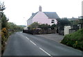
Pink house, Pentwyn Road, Abersychan
Located near the western end of Pentwyn Road.
Image: © Jaggery
Taken: 16 Apr 2011
0.03 miles
2
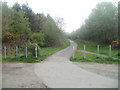
Cycle route, Pentwyn, Abersychan
Viewed from the SE end of The Promenade. National Cycle Network route 492 heads towards the village of Pentwyn.
Image: © Jaggery
Taken: 16 Apr 2011
0.04 miles
3
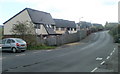
Pentwyn Heights, Abersychan
Modern housing viewed from Pentwyn Road.
Image: © Jaggery
Taken: 16 Apr 2011
0.04 miles
4
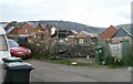
Construction site, Pentwyn, Abersychan
Located on the site of the demolished Pentwyn School.
Image: © Jaggery
Taken: 16 Apr 2011
0.05 miles
5
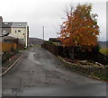
Unnamed side road, Pentwyn, Torfaen
Ascending from the west side of Pentwyn Road. Ahead for Caradoc Street.
Image: © Jaggery
Taken: 6 Nov 2018
0.06 miles
6
Underpass to Pentwyn Road, Abersychan
Viewed from this barrier. http://www.geograph.org.uk/photo/3409155 The path beneath the underpass leads up to Pentwyn Road.
Image: © Jaggery
Taken: 16 Apr 2011
0.07 miles
7
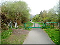
Barrier across a path, Pentwyn, Abersychan
The barrier is intended to prevent misuse of the path and cycle route by motor vehicles.
Walkers and cyclists can bypass the barrier via the side route on the left.
Image: © Jaggery
Taken: 16 Apr 2011
0.07 miles
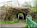
8
Underpass to cycle route 46, Pentwyn, Abersychan
The path connects Pentwyn Road on the camera side
with National Cycle Network route 46 on the far side of the underpass.
The underpass used to be beneath a railway line.
Image: © Jaggery
Taken: 16 Apr 2011
0.08 miles
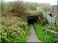
9
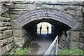
Underpass to cycle route from Pentwyn Road
The subway goes under a former LNWR trackbed to NCR 492.
Image: © M J Roscoe
Taken: 25 Feb 2022
0.08 miles
10
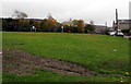
Recreation ground in Pentwyn, Torfaen
On the west side of Pentwyn Road.
Image: © Jaggery
Taken: 6 Nov 2018
0.08 miles