IMAGES TAKEN NEAR TO
Roundstables, PONTYPOOL, NP4 7TQ
Introduction
This page details the photographs taken nearby to Roundstables, NP4 7TQ by members of the Geograph project.
The Geograph project started in 2005 with the aim of publishing, organising and preserving representative images for every square kilometre of Great Britain, Ireland and the Isle of Man.

There are currently over 7.5m images from over14,400 individuals and you can help contribute to the project by visiting https://www.geograph.org.uk
Image Map
Images are licensed for reuse under creativecommons.org/licenses/by-sa/2.0
Notes
- Clicking on the map will re-center to the selected point.
- The higher the marker number, the further away the image location is from the centre of the postcode.
Image Listing (58 Images Found)
Images are licensed for reuse under creativecommons.org/licenses/by-sa/2.0
Image
Details
Distance
1
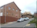
House construction, Pentwyn, Abersychan
Houses are being built on a road without, as yet, any street name signs. The road connects with Pentwyn Road behind the camera.
Image: © Jaggery
Taken: 16 Apr 2011
0.07 miles
2
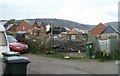
Construction site, Pentwyn, Abersychan
Located on the site of the demolished Pentwyn School.
Image: © Jaggery
Taken: 16 Apr 2011
0.08 miles
3
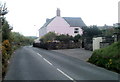
Pink house, Pentwyn Road, Abersychan
Located near the western end of Pentwyn Road.
Image: © Jaggery
Taken: 16 Apr 2011
0.11 miles
4
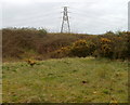
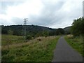
Pylon on high ground, Pentwyn, Abersychan
Viewed from a side road to the south of The Promenade.
Image: © Jaggery
Taken: 16 Apr 2011
0.13 miles
5
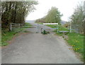
Barrier on NCR route 46 near Pentwyn
National Cycle Network route 46 here uses the trackbed of a dismantled railway.
The sign at the barrier states NO MOTOR VEHICLES EXCEPT DISABLED CARRIAGES.
Image: © Jaggery
Taken: 16 Apr 2011
0.14 miles
6
Cycle route (former railway) near Pen-twyn
Image: © David Smith
Taken: 26 Sep 2021
0.15 miles
7
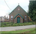
Pentwyn Chapel, Abersychan
Located on the west side of Pentwyn Terrace, opposite the post office. http://www.geograph.org.uk/photo/2365002
Image: © Jaggery
Taken: 16 Apr 2011
0.15 miles
8
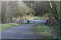
Cycle route 492 at Pentwyn Road
The cycleway goes down through the squeeze stile to cross the end of Pentwyn Road and continues to the right on a former railway line Image
Image: © M J Roscoe
Taken: 25 Feb 2022
0.15 miles
9
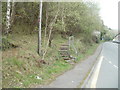
Steps from Foundry Road into a wood, Abersychan
Opposite the eastern edge of Cleaves Terrace, http://www.geograph.org.uk/photo/2360254 steps lead to a path into a wood.
Image: © Jaggery
Taken: 16 Apr 2011
0.16 miles
10
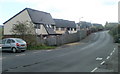
Pentwyn Heights, Abersychan
Modern housing viewed from Pentwyn Road.
Image: © Jaggery
Taken: 16 Apr 2011
0.16 miles