IMAGES TAKEN NEAR TO
The Landing, PONTYPOOL, NP4 7TL
Introduction
This page details the photographs taken nearby to The Landing, NP4 7TL by members of the Geograph project.
The Geograph project started in 2005 with the aim of publishing, organising and preserving representative images for every square kilometre of Great Britain, Ireland and the Isle of Man.

There are currently over 7.5m images from over14,400 individuals and you can help contribute to the project by visiting https://www.geograph.org.uk
Image Map
Images are licensed for reuse under creativecommons.org/licenses/by-sa/2.0
Notes
- Clicking on the map will re-center to the selected point.
- The higher the marker number, the further away the image location is from the centre of the postcode.
Image Listing (19 Images Found)
Images are licensed for reuse under creativecommons.org/licenses/by-sa/2.0
Image
Details
Distance
1
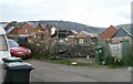
Construction site, Pentwyn, Abersychan
Located on the site of the demolished Pentwyn School.
Image: © Jaggery
Taken: 16 Apr 2011
0.18 miles
2
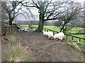
Footpath to Abersychan
Don't mind us, we're just grazing the footpath.
Image: © Graham Horn
Taken: 3 Feb 2008
0.18 miles
3
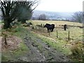
Byway to Pentre-Piod
This restricted byway comes off the moors and through a small farm as it descends to Pentre-Piod (not seen). In the distance is Trevethin, above Pontypool.
Image: © Graham Horn
Taken: 3 Feb 2008
0.19 miles
4
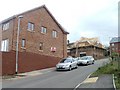
House construction, Pentwyn, Abersychan
Houses are being built on a road without, as yet, any street name signs. The road connects with Pentwyn Road behind the camera.
Image: © Jaggery
Taken: 16 Apr 2011
0.19 miles
5
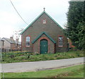
Pentwyn Chapel, Abersychan
Located on the west side of Pentwyn Terrace, opposite the post office. http://www.geograph.org.uk/photo/2365002
Image: © Jaggery
Taken: 16 Apr 2011
0.20 miles
6
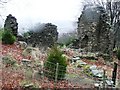
Ruined farm building
This ruined building still appears on 1:25K map. It is more likely to be a farm building rather than a mining one because of its location on a byway to the moors just above the enclosed fields.
Image: © Graham Horn
Taken: 3 Feb 2008
0.22 miles
7
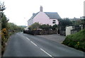
Pink house, Pentwyn Road, Abersychan
Located near the western end of Pentwyn Road.
Image: © Jaggery
Taken: 16 Apr 2011
0.22 miles
8
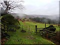
How green is my valley?
Only just a few hundred yards away from grey mine spoil heaps and industrial remains, this footpath passes through very green farmland above Abersychan.
Image: © Graham Horn
Taken: 3 Feb 2008
0.23 miles
9
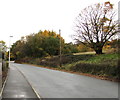
Early November 2018 colours, Pentwyn, Torfaen
Viewed across Pentwyn Road on November 6th 2018.
Image: © Jaggery
Taken: 6 Nov 2018
0.23 miles
10
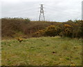
Pylon on high ground, Pentwyn, Abersychan
Viewed from a side road to the south of The Promenade.
Image: © Jaggery
Taken: 16 Apr 2011
0.23 miles