IMAGES TAKEN NEAR TO
Severn View, PONTYPOOL, NP4 7SN
Introduction
This page details the photographs taken nearby to Severn View, NP4 7SN by members of the Geograph project.
The Geograph project started in 2005 with the aim of publishing, organising and preserving representative images for every square kilometre of Great Britain, Ireland and the Isle of Man.

There are currently over 7.5m images from over14,400 individuals and you can help contribute to the project by visiting https://www.geograph.org.uk
Image Map
Images are licensed for reuse under creativecommons.org/licenses/by-sa/2.0
Notes
- Clicking on the map will re-center to the selected point.
- The higher the marker number, the further away the image location is from the centre of the postcode.
Image Listing (68 Images Found)
Images are licensed for reuse under creativecommons.org/licenses/by-sa/2.0
Image
Details
Distance
1
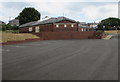
Garndiffaith Community Centre
Located in the Millennium Hall, Top Road, built in 2001. Viewed from the Stanley Road side.
This site was formerly occupied by Garndiffaith Elementary School.
Image: © Jaggery
Taken: 16 Jul 2018
0.12 miles
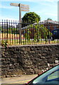
2
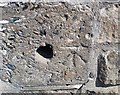
Ordnance Survey Cut Mark
This OS cut mark can be found on the school wall, Stanley Road. It marks a point 286.543m above mean sea level.
Image: © Adrian Dust
Taken: 25 Aug 2019
0.13 miles
3
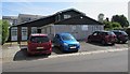
Garndiffaith Health Centre
Set back from Stanley Road in Garndiffaith.
Image: © Jaggery
Taken: 19 Jul 2018
0.13 miles
4
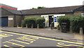
Garndiffaith Police Station
Part of the Gwent Police force viewed across a Stanley Road bus stop.
Image: © Jaggery
Taken: 16 Jul 2018
0.14 miles
5
Houses on the site of a demolished church, Stanley Road, Garndiffaith
Viewed in July 2018. An October 2009 Google Earth Street View shows the Church of St John the Evangelist with St Thomas in the Church in Wales Diocese of Monmouth here.
Image: © Jaggery
Taken: 19 Jul 2018
0.14 miles
6
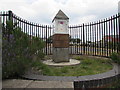
Pillar of the Community, Garndiffaith
Located at the SW edge of the former Garndiffaith Elementary School. The site is now occupied by Garndiffaith Community Centre. https://www.geograph.org.uk/photo/5852891 An information board records that Pillar of the Community is the work of designer and sculptor Mark Folds. Working with ideas from local residents, organisations and scholars, Mark designed the sculpture to reflect the people, places and history that make Garndiffaith such a vibrant community.
Image: © Jaggery
Taken: 16 Jul 2018
0.15 miles
7
Wooden signpost above Stanley Road, Garndiffaith
Community Link signpost in a corner of the Millennium Hall site.
Image: © Jaggery
Taken: 19 Jul 2018
0.15 miles
8
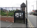
Garndiffaith Community Noticeboard
Alongside Stanley Road at the SW corner of the Garndiffaith Community Centre site. https://www.geograph.org.uk/photo/5852891
Image: © Jaggery
Taken: 16 Jul 2018
0.15 miles
9
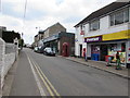
Stanley Road shops, Garndiffaith
In view in July 2018 are Garndiffaith Convenience Store, the Co-op and a Well Pharmacy.
Image: © Jaggery
Taken: 16 Jul 2018
0.15 miles
10
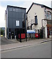
The Corn Bin, Stanley Road, Garndiffaith
Originally a bakehouse dating from the 19th century.
In July 2018 the name sign shows Torfaen County Borough Council - Communities First.
The banner shows that a Work Club is here from 10am to 12 noon every Thursday.
Image: © Jaggery
Taken: 16 Jul 2018
0.15 miles