IMAGES TAKEN NEAR TO
Varteg, PONTYPOOL, NP4 7RT
Introduction
This page details the photographs taken nearby to NP4 7RT by members of the Geograph project.
The Geograph project started in 2005 with the aim of publishing, organising and preserving representative images for every square kilometre of Great Britain, Ireland and the Isle of Man.

There are currently over 7.5m images from over14,400 individuals and you can help contribute to the project by visiting https://www.geograph.org.uk
Image Map
Images are licensed for reuse under creativecommons.org/licenses/by-sa/2.0
Notes
- Clicking on the map will re-center to the selected point.
- The higher the marker number, the further away the image location is from the centre of the postcode.
Image Listing (80 Images Found)
Images are licensed for reuse under creativecommons.org/licenses/by-sa/2.0
Image
Details
Distance
1
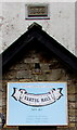
Year stone 1868, Varteg
Located here https://www.geograph.org.uk/photo/5711455 in the wall of Varteg Community Centre,
formerly Varteg Methodist Chapel which was built in 1824, rebuilt in 1868.
Image: © Jaggery
Taken: 15 Mar 2018
0.01 miles
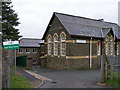
2
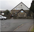
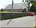
Varteg Community Centre, Varteg
Located in the former Varteg Methodist Chapel which was built in 1824, rebuilt in 1868. https://www.geograph.org.uk/photo/5711458
Image: © Jaggery
Taken: 15 Mar 2018
0.01 miles
3
Old cemetery in Varteg
Viewed from the entrance gates where a notice https://www.geograph.org.uk/photo/5711487 states
This cemetery is unsafe - persons entering do so at their own risk.
Originally Varteg Methodist Chapel, the building is now Varteg Community Centre. https://www.geograph.org.uk/photo/5711455
Image: © Jaggery
Taken: 15 Mar 2018
0.01 miles
5
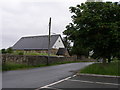
Field on the west side of Ysgol Bryn Onnen, Varteg
Ysgol Bryn Onnen is the village school.
Image: © Jaggery
Taken: 15 Mar 2018
0.02 miles
7
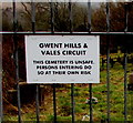
Unsafe cemetery warning notice, Varteg
On the gate here. https://www.geograph.org.uk/photo/5711482
Image: © Jaggery
Taken: 15 Mar 2018
0.04 miles
8

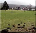
Molehills near the entrance to an old cemetery, Varteg
Viewed from Snail Creep Terrace looking towards the entrance to this https://www.geograph.org.uk/photo/5711472 disused cemetery.
Image: © Jaggery
Taken: 15 Mar 2018
0.04 miles
9
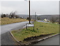
Bilingual Shop Road name sign, Varteg
Shop Road is Heol y Siop in Welsh.
Image: © Jaggery
Taken: 15 Mar 2018
0.04 miles
10
Varteg Community Centre
Built in 1828 as a Methodist chapel. The date plaque on the building records the year it was rebuilt, 1868.
Image: © Jaggery
Taken: 12 May 2010
0.04 miles