IMAGES TAKEN NEAR TO
Railway Close, Albert Road, PONTYPOOL, NP4 7RB
Introduction
This page details the photographs taken nearby to Railway Close, Albert Road, NP4 7RB by members of the Geograph project.
The Geograph project started in 2005 with the aim of publishing, organising and preserving representative images for every square kilometre of Great Britain, Ireland and the Isle of Man.

There are currently over 7.5m images from over14,400 individuals and you can help contribute to the project by visiting https://www.geograph.org.uk
Image Map
Images are licensed for reuse under creativecommons.org/licenses/by-sa/2.0
Notes
- Clicking on the map will re-center to the selected point.
- The higher the marker number, the further away the image location is from the centre of the postcode.
Image Listing (99 Images Found)
Images are licensed for reuse under creativecommons.org/licenses/by-sa/2.0
Image
Details
Distance
1
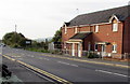
Railway Close houses opposite a bus stop, Talywain
Viewed across the B4246 Albert Road. The Farm Road turning is behind the house on the left.
Image: © Jaggery
Taken: 29 Sep 2015
0.01 miles
2
Albert Road name sign, Talywain
The name sign alongside the B4246 is in front of the white van. The houses are in Railway Close.
Image: © Jaggery
Taken: 29 Sep 2015
0.01 miles
3
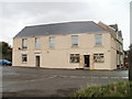
Hairdressers and corner shop, Albert Road, Talywain
Two business premises located at the corner of Pisgah Road and Albert Road. The right half of the building is an externally unnamed corner shop. Its neighbour is Bel-Air Studios, unisex salon.
Image: © Jaggery
Taken: 13 Apr 2011
0.02 miles
4
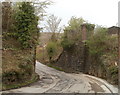
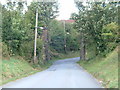
Remains of a railway bridge, Farm Road, Talywain
At a bend on Farm Road, near the junction with the B4246, is the masonry of a former railway bridge.
Image: © Jaggery
Taken: 13 Apr 2011
0.02 miles
5
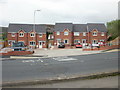
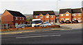
Railway Close, Talywain
Recently-built houses set back from Albert Road.
Image: © Jaggery
Taken: 12 May 2010
0.02 miles
6
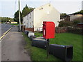
Queen Elizabeth II postbox, Albert Road, Talywain
Old wheelie bins, http://www.geograph.org.uk/photo/4678856 some without wheels, have been dumped near the postbox.
Image: © Jaggery
Taken: 29 Sep 2015
0.02 miles
7
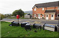
Dead wheelie bins in Talywain
Alongside an Albert Road bus stop lie wheelie bins and some of their detached wheels.
The word COPPER is on the bin on the right.
Image: © Jaggery
Taken: 29 Sep 2015
0.02 miles
8
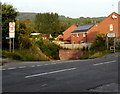
Junction of Commercial Road and Farm Road, Talywain
Farm Road descends from the B4246 Commercial Road towards Castle Wood and The British Industrial Estate.
The sign on the left shows that Farm Road is liable to flooding.
Image: © Jaggery
Taken: 29 Sep 2015
0.03 miles
9
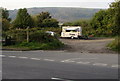
Albies Refreshments, Talywain
In a small car park on the corner of the B4246 Commercial Road and Farm Road.
Image: © Jaggery
Taken: 29 Sep 2015
0.04 miles