IMAGES TAKEN NEAR TO
New Road, PONTYPOOL, NP4 7QX
Introduction
This page details the photographs taken nearby to New Road, NP4 7QX by members of the Geograph project.
The Geograph project started in 2005 with the aim of publishing, organising and preserving representative images for every square kilometre of Great Britain, Ireland and the Isle of Man.

There are currently over 7.5m images from over14,400 individuals and you can help contribute to the project by visiting https://www.geograph.org.uk
Image Map
Images are licensed for reuse under creativecommons.org/licenses/by-sa/2.0
Notes
- Clicking on the map will re-center to the selected point.
- The higher the marker number, the further away the image location is from the centre of the postcode.
Image Listing (59 Images Found)
Images are licensed for reuse under creativecommons.org/licenses/by-sa/2.0
Image
Details
Distance
1
Garn Motorcycles, Garndiffaith
Located on New Road. Services include motorcycle MOT centre; new and used motorbikes for sale; repairs, servicing and tyres ; breakdown recovery.
Image: © Jaggery
Taken: 12 May 2010
0.04 miles
2
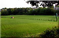
The Ravine Ground, Garndiffaith
The home ground of Fairfield United football club is set below the B4246, on land near a stream, Nant Ffrwd. Access to the ground is from here. http://www.geograph.org.uk/photo/4678661
Image: © Jaggery
Taken: 29 Sep 2015
0.06 miles
3
Welcome to Garndiffaith and Varteg
The Welcome signs are alongside the B4246 at the southern edge of Garndiffaith,
viewed from the northern edge of Talywain, in Torfaen County Borough.
Image: © Jaggery
Taken: 29 Sep 2015
0.08 miles
4
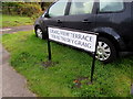
Bilingual street name sign, Graig View Terrace, Talywain
The English and Welsh names are on the north side of this http://www.geograph.org.uk/photo/4678599 row of houses.
Image: © Jaggery
Taken: 29 Sep 2015
0.09 miles
5
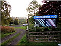
Entrance to the Ravine Ground Garndiffaith
On the east side of the B4246 Emlyn Road, this is the entrance to the Ravine Ground, http://www.geograph.org.uk/photo/4678677 the home of Fairfield United AFC (Association Football Club). Based on the location of this http://www.geograph.org.uk/photo/4678607 nearby boundary sign,
the entrance is in Talywain but most of the football ground is in Garndiffaith.
Image: © Jaggery
Taken: 29 Sep 2015
0.09 miles
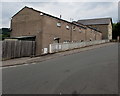
6
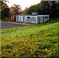
Ravine Ground pavilion, Garndiffaith
The building is above the southern edge of Fairfield United's home ground. http://www.geograph.org.uk/photo/4678677
Image: © Jaggery
Taken: 29 Sep 2015
0.10 miles
7
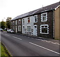
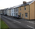
Graig View Terrace, Talywain
Row of four houses at the northern edge of Talywain, viewed across the B4246.
Image: © Jaggery
Taken: 29 Sep 2015
0.11 miles
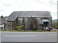
8
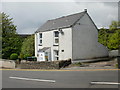
Birchill Cottage, Garndiffaith
Located on New Road (B4246)
Image: © Jaggery
Taken: 12 May 2010
0.12 miles
9
Emlyn Road houses, Talywain
Viewed across the B4246, here named Emlyn Road. The Green Way junction is on the right.
Image: © Jaggery
Taken: 29 Sep 2015
0.12 miles
10
Row of houses near Bethel Methodist Church, Garndiffaith
The church https://www.geograph.org.uk/photo/5844207 is on the right.
Image: © Jaggery
Taken: 16 Jul 2018
0.13 miles