IMAGES TAKEN NEAR TO
Varteg Road, PONTYPOOL, NP4 7PX
Introduction
This page details the photographs taken nearby to Varteg Road, NP4 7PX by members of the Geograph project.
The Geograph project started in 2005 with the aim of publishing, organising and preserving representative images for every square kilometre of Great Britain, Ireland and the Isle of Man.

There are currently over 7.5m images from over14,400 individuals and you can help contribute to the project by visiting https://www.geograph.org.uk
Image Map
Images are licensed for reuse under creativecommons.org/licenses/by-sa/2.0
Notes
- Clicking on the map will re-center to the selected point.
- The higher the marker number, the further away the image location is from the centre of the postcode.
Image Listing (71 Images Found)
Images are licensed for reuse under creativecommons.org/licenses/by-sa/2.0
Image
Details
Distance
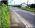
2
Varteg Road from Varteg towards Blaenavon
Looking north along the B4246 Varteg Road during heavy rain on May 11th 2017.
The road here is about 340 metres (c1,115 ft) above mean sea level.
Image: © Jaggery
Taken: 11 May 2017
0.01 miles
3
Kears Row/Rhes Kears name sign in Varteg
English/Welsh sign facing the B4246 Varteg Road near this https://www.geograph.org.uk/photo/6394809 row of houses.
Image: © Jaggery
Taken: 15 Mar 2018
0.03 miles
4
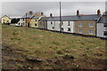
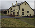
Kears Row, Varteg
Row of houses below the east side of the B4246 Varteg Road. The Coflein website records that Kears Row was originally a row of four early 19th century houses built for workmen associated with Varteg Ironworks. The first edition Ordnance Survey shows a brewery at the end of the row, probably now the yellow house. The two larger houses to the left of the yellow house were built in the 20th century. The Crown Hotel https://www.geograph.org.uk/photo/5708130 is at the left edge of the photo.
Image: © Jaggery
Taken: 15 Mar 2018
0.03 miles
5
Crown depiction on the Crown Hotel, Varteg
The Crown Hotel pub is set back from the east side of the B4246 Varteg Road. The Coflein website records that the building is said to date from 1784 and to have become a public house in 1870. The Tithe Survey marked it as Varteg Shop. Shown on the first edition Ordnance Survey, but not as a public house. Formerly owned by the Rhymney Brewery Company.
Image: © Jaggery
Taken: 15 Mar 2018
0.03 miles
6
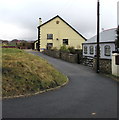
South side of the Crown Hotel, Varteg
A crown depiction is on the wall on the south side of the Crown Hotel. https://www.geograph.org.uk/photo/5708130 Viewed in March 2018. The grey bungalow was built in the second decade of the 21st century. It is not in a May 2011 Google Street View.
Image: © Jaggery
Taken: 15 Mar 2018
0.03 miles
7
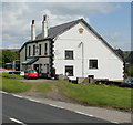
Crown Hotel, Varteg
Pub with bed and breakfast accommodation available.
Located alongside the B4246 Varteg Road.
Image: © Jaggery
Taken: 12 May 2010
0.04 miles
8
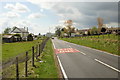
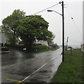
Welcome to Varteg
The B4246 from Blaenavon approaches Varteg. Just beyond the SLOW/ARAF markings in the road, a welcome sign shows Varteg and Garndiffaith. The latter village is about a kilometre south of Varteg.
The white building on the left is the Crown Hotel. http://www.geograph.org.uk/photo/1855453
Image: © Jaggery
Taken: 12 May 2010
0.04 miles
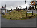
9
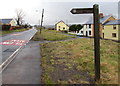
Cwm Ffrwd Heritage Trail direction sign, Varteg
The sign alongside the B4246 Varteg Road points towards Salisbury Terrace. https://www.geograph.org.uk/photo/6394821
Image: © Jaggery
Taken: 15 Mar 2018
0.04 miles
10
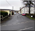
WNW along Salisbury Terrace, Varteg
From the B4246 Varteg Road, Salisbury Terrace leads to Pembroke Place and Pembroke Terrace.
Image: © Jaggery
Taken: 15 Mar 2018
0.04 miles