IMAGES TAKEN NEAR TO
Woodlands, PONTYPOOL, NP4 7LD
Introduction
This page details the photographs taken nearby to Woodlands, NP4 7LD by members of the Geograph project.
The Geograph project started in 2005 with the aim of publishing, organising and preserving representative images for every square kilometre of Great Britain, Ireland and the Isle of Man.

There are currently over 7.5m images from over14,400 individuals and you can help contribute to the project by visiting https://www.geograph.org.uk
Image Map
Images are licensed for reuse under creativecommons.org/licenses/by-sa/2.0
Notes
- Clicking on the map will re-center to the selected point.
- The higher the marker number, the further away the image location is from the centre of the postcode.
Image Listing (113 Images Found)
Images are licensed for reuse under creativecommons.org/licenses/by-sa/2.0
Image
Details
Distance
1
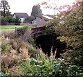
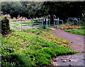
Bridge over a long disused former railway, Talywain
North of Commercial Close. The former railway trackbed is now a footpath.
Image: © Jaggery
Taken: 29 Sep 2015
0.00 miles
2
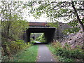
Bridge over former railway near Talywain
Image: © Gareth James
Taken: 15 Oct 2011
0.02 miles
3
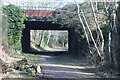
Bridge over Afon Lwyd Trail, NCR 492
Cycle way on former LNWR Abersychan Extension Branch.
Image: © M J Roscoe
Taken: 25 Feb 2022
0.02 miles
4
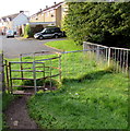
Kissing gate near Commercial Close, Talywain
Giving walkers on a footpath behind the camera access to Commercial Close.
Image: © Jaggery
Taken: 29 Sep 2015
0.02 miles
5
Barrier across a Talywain path near Pisgah Road
To access this path http://www.geograph.org.uk/photo/4679696 walkers can pass through the inwardly-sloping barrier on the right.
Image: © Jaggery
Taken: 29 Sep 2015
0.02 miles
6
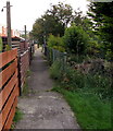
Path NE of Commercial Road, Talywain
Past fences at the SE edge of four parallel rows of houses south of Pisgah Road.
Image: © Jaggery
Taken: 29 Sep 2015
0.03 miles
7
Northern end of the Commercial Close roadway, Talywain
The road ends at grass about 20 metres beyond the northernmost houses in the close.
Image: © Jaggery
Taken: 29 Sep 2015
0.03 miles
8
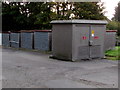
Pisgah Road electricity substation, Talywain
The Western Power Distribution electricity substation identifier is
PISGAH ROAD TALYWAIN S/S No 53-2605.
Image: © Jaggery
Taken: 29 Sep 2015
0.03 miles
9
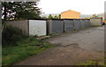
Row of lockup garages, Talywain
South of Pisgah Road. The back of an electricity substation http://www.geograph.org.uk/photo/4679644 is in the background.
Image: © Jaggery
Taken: 29 Sep 2015
0.03 miles
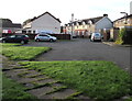
10
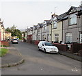
Commercial Close, Talywain
Dead-end street below the B4246 Commercial Road.
Image: © Jaggery
Taken: 29 Sep 2015
0.04 miles