IMAGES TAKEN NEAR TO
Blue Boar, PONTYPOOL, NP4 7LB
Introduction
This page details the photographs taken nearby to Blue Boar, NP4 7LB by members of the Geograph project.
The Geograph project started in 2005 with the aim of publishing, organising and preserving representative images for every square kilometre of Great Britain, Ireland and the Isle of Man.

There are currently over 7.5m images from over14,400 individuals and you can help contribute to the project by visiting https://www.geograph.org.uk
Image Map
Images are licensed for reuse under creativecommons.org/licenses/by-sa/2.0
Notes
- Clicking on the map will re-center to the selected point.
- The higher the marker number, the further away the image location is from the centre of the postcode.
Image Listing (98 Images Found)
Images are licensed for reuse under creativecommons.org/licenses/by-sa/2.0
Image
Details
Distance
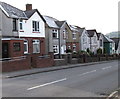
1
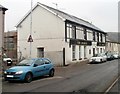
The Dagmar, Talywain
Pub at 70 Commercial Road. Extensive internal renovation work was in progress at the date of this view, mid-April 2011. Scaffolding can be seen on the left.
Image: © Jaggery
Taken: 13 Apr 2011
0.05 miles
2
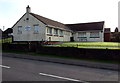
Talywain Senior Citizens Hall
Viewed across the B4246 Church Road in late September 2015.
The notice on the left shows Meetings on Thursdays at 2.30pm. Bingo every Friday evening at 7pm.
Image: © Jaggery
Taken: 29 Sep 2015
0.07 miles
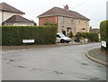
3
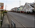
Up Church Road, Talywain
The B4246 Church Road is part of a long ascent from Abersychan to Blaenavon.
Image: © Jaggery
Taken: 29 Sep 2015
0.07 miles
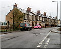
5
Church Road houses, Talywain
On the east side of the B4246 Church Road.
Image: © Jaggery
Taken: 29 Sep 2015
0.09 miles
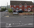
6
Corner of Wellington Road and Waterloo Road, Talywain
Viewed across Waterloo Road.
Image: © Jaggery
Taken: 13 Apr 2011
0.09 miles
7
Coed Terrace, Waterloo Road, Talywain
This section of Waterloo Road is named Coed Terrace.
Image: © Jaggery
Taken: 13 Apr 2011
0.09 miles
8
St Francis Close, Talywain
This part of St Francis Close (Clos Sant Ffransis in Welsh) is on the corner of the B4246 Church Road, viewed in late September 2015. These houses were built in the second decade of the 21st century. A June 2011 Google Earth Street View shows a building site here with rubble and building materials, but no houses.
Image: © Jaggery
Taken: 29 Sep 2015
0.09 miles
9
Heol Waun field gates, Talywain
The gates on the corner of Heol Waun and Church Road gives access to a field
on the north side of houses in St Francis Close, http://www.geograph.org.uk/photo/4681361 built in 2011-2012.
Image: © Jaggery
Taken: 29 Sep 2015
0.09 miles
10
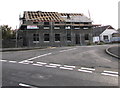
House construction on the site of the former the British Constitution Inn, Talywain
Viewed in late September 2015. The Cons (British Constitution Inn) which occupied this site, 41 Commercial Road, was demolished before this construction began. http://www.geograph.org.uk/photo/1857701 to The Cons in May 2010.
Image: © Jaggery
Taken: 29 Sep 2015
0.10 miles