IMAGES TAKEN NEAR TO
Co-Operative Terrace, PONTYPOOL, NP4 7JD
Introduction
This page details the photographs taken nearby to Co-Operative Terrace, NP4 7JD by members of the Geograph project.
The Geograph project started in 2005 with the aim of publishing, organising and preserving representative images for every square kilometre of Great Britain, Ireland and the Isle of Man.

There are currently over 7.5m images from over14,400 individuals and you can help contribute to the project by visiting https://www.geograph.org.uk
Image Map
Images are licensed for reuse under creativecommons.org/licenses/by-sa/2.0
Notes
- Clicking on the map will re-center to the selected point.
- The higher the marker number, the further away the image location is from the centre of the postcode.
Image Listing (117 Images Found)
Images are licensed for reuse under creativecommons.org/licenses/by-sa/2.0
Image
Details
Distance
1
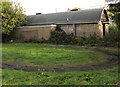
Derelict former St Thomas Church Hall, Talywain
Viewed across Bluetts Road in late September 2015. Displayed on railings nearby, http://www.geograph.org.uk/photo/4680093 a Torfaen Borough Council Notice of Application for Planning Permission dated September 23rd 2015 gives details of a proposal to convert the hall to two dwellings. Any comments on the proposal must be received by the Council Planning Officer by October 14th 2015 in order to be considered when deciding this application.
Image: © Jaggery
Taken: 29 Sep 2015
0.02 miles
2
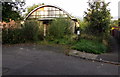
Modern bungalow and derelict former church hall in Talywain
Viewed across Bluetts Road. The derelict former St Thomas Church Hall http://www.geograph.org.uk/photo/4680068 is on the right.
Image: © Jaggery
Taken: 29 Sep 2015
0.02 miles
3
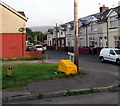
Yellow and green corner of Commercial Close, Talywain
Yellow grit box and yellow hydrant marker.
Image: © Jaggery
Taken: 29 Sep 2015
0.02 miles
4
Overgrown former church hall in Talywain
In late September 2015, weeds partially hide the former St Thomas Church Hall in Bluetts Road.
A Torfaen Borough Council Notice of Application for Planning Permission is on the railings.
See http://www.geograph.org.uk/photo/4680068 for another view of the building and details of the notice contents.
Image: © Jaggery
Taken: 29 Sep 2015
0.03 miles
5
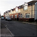
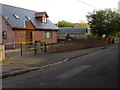
West side of Commercial Close, Talywain
Windows on the east-facing houses reflect sunshine at 8.30am in late September 2015.
Image: © Jaggery
Taken: 29 Sep 2015
0.03 miles
6
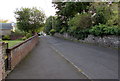
Bluetts Road, Talywain
From the Commercial Road end looking in the direction of the street named Ambleside.
The edge of a derelict former church hall http://www.geograph.org.uk/photo/4680068 is on the left.
Image: © Jaggery
Taken: 29 Sep 2015
0.04 miles
7
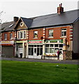
Talywain Stores and Post Office
At 79 Commercial Road, Talywain. Family Pizza House http://www.geograph.org.uk/photo/4680026 at number 77 is on the left.
Image: © Jaggery
Taken: 29 Sep 2015
0.04 miles
8
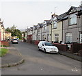
Commercial Close, Talywain
Dead-end street below the B4246 Commercial Road.
Image: © Jaggery
Taken: 29 Sep 2015
0.05 miles
9
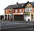
Family Pizza House, Talywain
The takeaway at 77 Commercial Road sells pizzas, kebabs, burgers, fish & chips etc.
Image: © Jaggery
Taken: 29 Sep 2015
0.05 miles
10
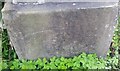
Ordnance Survey Cut Mark
This OS cut mark can be found on the west angle of St Thomas Church. It marks a point 252.088m above mean sea level.
Image: © Adrian Dust
Taken: 25 Aug 2019
0.05 miles