IMAGES TAKEN NEAR TO
Lodge Road, PONTYPOOL, NP4 7ED
Introduction
This page details the photographs taken nearby to Lodge Road, NP4 7ED by members of the Geograph project.
The Geograph project started in 2005 with the aim of publishing, organising and preserving representative images for every square kilometre of Great Britain, Ireland and the Isle of Man.

There are currently over 7.5m images from over14,400 individuals and you can help contribute to the project by visiting https://www.geograph.org.uk
Image Map
Images are licensed for reuse under creativecommons.org/licenses/by-sa/2.0
Notes
- Clicking on the map will re-center to the selected point.
- The higher the marker number, the further away the image location is from the centre of the postcode.
Image Listing (97 Images Found)
Images are licensed for reuse under creativecommons.org/licenses/by-sa/2.0
Image
Details
Distance
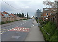
1
Bilingual name sign, Lodge Road, Abersychan
The sign on the left, on the corner of Church Road, shows that Lodge Road is Heol y Porthdy in Welsh.
Image: © Jaggery
Taken: 6 Nov 2018
0.01 miles
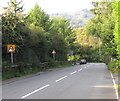
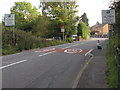
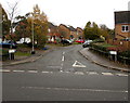
2

Junction in the south of Talywain
Church Road, the B4246 from the left, descends ahead into Abersychan as an unclassified road.
The B4246 continues on the right as Lodge Road.
Image: © Jaggery
Taken: 29 Sep 2015
0.02 miles
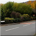
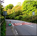
3
Two bend warning signs, Talywain
The two signs alongside the B4246 Lodge Road differ both in appearance and content. The nearer one depicts a left bend. The other one depicts a left bend with a small spot on the right of the bend, indicating a minor junction on the right side of the bend ahead.
Image: © Jaggery
Taken: 29 Sep 2015
0.03 miles
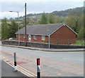
4
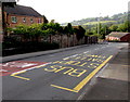
Church Road stop for northbound buses, Talywain
The stop is on the B4246 Church Road, on its long ascent from Abersychan to Blaenavon.
Image: © Jaggery
Taken: 29 Sep 2015
0.03 miles
5
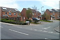
British School Close, Abersychan
Modern houses at the northern edge of Abersychan, a few metres from the Talywain boundary. http://www.geograph.org.uk/photo/2372058
Image: © Jaggery
Taken: 16 Apr 2011
0.03 miles
6
Southern boundary of Talywain
The B4246 leaves Abersychan and enters Talywain opposite the turning for British School Close. http://www.geograph.org.uk/photo/2372048
UPDATE In September 2015, Talywain's southern boundary signs http://www.geograph.org.uk/photo/4681559 are more than 100 metres further south.
Image: © Jaggery
Taken: 16 Apr 2011
0.03 miles
7
The Conifers, Abersychan
Long bungalow on the corner of Church Road and Lodge Road.
Image: © Jaggery
Taken: 16 Apr 2011
0.04 miles
8
Welcome to Talywain - please drive carefully
This is the southern boundary of Talywain in September 2015, on the B4246 Lodge Road.
In April 2011, the village's southern boundary was more than 100 metres further north, near British School Close, as seen here. http://www.geograph.org.uk/photo/2372058
Image: © Jaggery
Taken: 29 Sep 2015
0.04 miles
9
From Talywain to Abersychan
The B4246 Lodge Road passes the grey backs of Welcome to Talywain signs. http://www.geograph.org.uk/photo/4681559
Image: © Jaggery
Taken: 29 Sep 2015
0.04 miles
10
British School Close at the northern edge of Abersychan
Cul-de-sac viewed across the B4246 Church Road.
Image: © Jaggery
Taken: 6 Nov 2018
0.06 miles