IMAGES TAKEN NEAR TO
Pantygasseg, PONTYPOOL, NP4 6UJ
Introduction
This page details the photographs taken nearby to NP4 6UJ by members of the Geograph project.
The Geograph project started in 2005 with the aim of publishing, organising and preserving representative images for every square kilometre of Great Britain, Ireland and the Isle of Man.

There are currently over 7.5m images from over14,400 individuals and you can help contribute to the project by visiting https://www.geograph.org.uk
Image Map
Images are licensed for reuse under creativecommons.org/licenses/by-sa/2.0
Notes
- Clicking on the map will re-center to the selected point.
- The higher the marker number, the further away the image location is from the centre of the postcode.
Image Listing (9 Images Found)
Images are licensed for reuse under creativecommons.org/licenses/by-sa/2.0
Image
Details
Distance
1
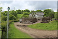
Partly demolished barn, Ty-gwyn Cottages
The two cottages Image, sometimes apparently also referred to as Old Black Barn Farm, are on a restricted byway, the route of the former Blaen-y-Cwm Railroad, here running parallel with Blaen-y-cwm Road.
Image: © M J Roscoe
Taken: 21 May 2017
0.00 miles
2
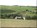
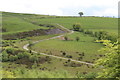
Ty-gwyn Cottages
The cottages are numbers 1 and 2 Ty Gwyn Cottages. The land surrounding them belongs to a farm along the tram-road to Pantygasseg. The barn to the left of the cottages was once used to shoe horses.
This is an area with much evidence of former mine-working. There is a disused tip beyond it. Ty Mary-Harry mine shaft (disused) is nearby. Behind the photographer is an area of unfenced grazing land over Cefn-Crib.
Image: © Jessica Aidley
Taken: 6 Jul 2007
0.01 miles
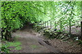
3
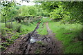
Grass track, south to Ty-gwyn Cottages
Restricted byway, route of the former Blaen-y-Cwm Railroad, going to Ty-gwyn Image
Image: © M J Roscoe
Taken: 21 May 2017
0.05 miles
4
Windblown tree on Cefn Crib
The way the prevailing wind has shaped this tree is very obvious. The branches downwind are longer than those upwind.
Image: © Jessica Aidley
Taken: 6 Jul 2007
0.16 miles
5
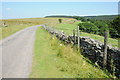
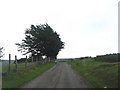
Blaen-y-cwm Road
Blaen-y-cwm Road follows the edge of open grazing land named Cefn Crib which is on the left.
Image: © Philip Halling
Taken: 10 Aug 2012
0.17 miles
6
Track south from Tir Ysgubor Ddu
Restricted byway, route of the former Blaen-y-Cwm Railroad, lined on the eastern side by beech trees, a northern continuation of byway Image
Image: © M J Roscoe
Taken: 21 May 2017
0.19 miles
7
Track next to old colliery workings
Old colliery waste tip at the site of the former Tir-pentwys colliery, now grazing land for sheep.
Image: © M J Roscoe
Taken: 21 May 2017
0.20 miles
8
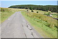
Blaen-y-cwm Road
Blaen-y-cwm Road crossing Cefn Crib.
Image: © Philip Halling
Taken: 10 Aug 2012
0.20 miles
9
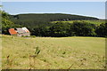
Barn above Blaen-y-cwm
Old partially roofed barn above Blaen-y-cwm, viewed here from Blaen-y-cwm Farm.
Image: © Philip Halling
Taken: 10 Aug 2012
0.21 miles