IMAGES TAKEN NEAR TO
Snatchwood View, PONTYPOOL, NP4 6TZ
Introduction
This page details the photographs taken nearby to Snatchwood View, NP4 6TZ by members of the Geograph project.
The Geograph project started in 2005 with the aim of publishing, organising and preserving representative images for every square kilometre of Great Britain, Ireland and the Isle of Man.

There are currently over 7.5m images from over14,400 individuals and you can help contribute to the project by visiting https://www.geograph.org.uk
Image Map
Images are licensed for reuse under creativecommons.org/licenses/by-sa/2.0
Notes
- Clicking on the map will re-center to the selected point.
- The higher the marker number, the further away the image location is from the centre of the postcode.
Image Listing (76 Images Found)
Images are licensed for reuse under creativecommons.org/licenses/by-sa/2.0
Image
Details
Distance
1
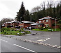
Snatchwood View houses, Pontnewynydd
Viewed across the A4043 Snatchwood Road.
The houses are in the north of Pontnewynydd, near the Abersychan boundary sign. http://www.geograph.org.uk/photo/4770093
Image: © Jaggery
Taken: 17 Dec 2015
0.01 miles
2
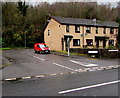
Royal Mail van, Snatchwood Court, Pontnewynydd
Viewed across the A4043 Snatchwood Road.
Snatchwood Court is in the north of Pontnewynydd, near the Abersychan boundary sign. http://www.geograph.org.uk/photo/4770093
Image: © Jaggery
Taken: 17 Dec 2015
0.05 miles
3
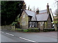
The Lodge, Snatchwood Road, Pontnewynydd
Detached house viewed across the A4043 Snatchwood Road in the north of Pontnewynydd.
Image: © Jaggery
Taken: 17 Dec 2015
0.06 miles
4
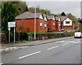
Welcome to Abersychan
In Torfaen county borough, the A4043 Snatchwood Road from Pontnewynydd passes the southern boundary of Abersychan.
Image: © Jaggery
Taken: 17 Dec 2015
0.06 miles
5
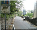
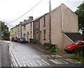
Narrow Lower Leigh Road, Pontnewynydd
Walkers need to proceed carefully ahead - there are no pavements and the road is narrow.
Image: © Jaggery
Taken: 9 May 2011
0.08 miles
6
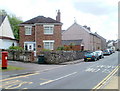
Freeholdland Road houses, Pontnewynydd
A detached house and a short row of houses are on the eastern side of Freeholdland Road, viewed from near the point where the road (the B4246) is renamed Limekiln Road, behind the camera.
Image: © Jaggery
Taken: 9 May 2011
0.08 miles
7
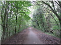
Woodland tunnel on NCN Route 46 near Pentre-Piod
Image: © Gareth James
Taken: 15 Oct 2011
0.10 miles
8
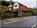
Snatchwood bus stop and shelter opposite Primrose Lane, Abersychan
This stop alongside the A4043 Snatchwood Road is for northbound buses,
towards the centre of Abersychan, and beyond to Blaenavon via Talywain and Varteg.
Image: © Jaggery
Taken: 17 Dec 2015
0.10 miles
9
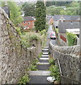
Steps descend from Lower Leigh Road, Pontnewynydd
The steps are at the SE end of a row of houses. http://www.geograph.org.uk/photo/2412244
The path leads to Fairfields, Park View and Freeholdland Road.
Image: © Jaggery
Taken: 9 May 2011
0.11 miles
10
Lower Leigh Road houses, Pontnewynydd
Houses on the south side of the road, about 70 metres SE of the entrance http://www.geograph.org.uk/photo/2412227 to Pontnewynydd Primary School.
Image: © Jaggery
Taken: 9 May 2011
0.11 miles