IMAGES TAKEN NEAR TO
Pantygasseg, PONTYPOOL, NP4 6TY
Introduction
This page details the photographs taken nearby to NP4 6TY by members of the Geograph project.
The Geograph project started in 2005 with the aim of publishing, organising and preserving representative images for every square kilometre of Great Britain, Ireland and the Isle of Man.

There are currently over 7.5m images from over14,400 individuals and you can help contribute to the project by visiting https://www.geograph.org.uk
Image Map
Images are licensed for reuse under creativecommons.org/licenses/by-sa/2.0
Notes
- Clicking on the map will re-center to the selected point.
- The higher the marker number, the further away the image location is from the centre of the postcode.
Image Listing (16 Images Found)
Images are licensed for reuse under creativecommons.org/licenses/by-sa/2.0
Image
Details
Distance
1
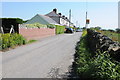
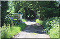
Houses at Pantygasseg
Road passing houses at Pantygasseg high above Cwm y Glyn.
Image: © Philip Halling
Taken: 10 Aug 2012
0.02 miles
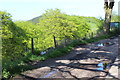
3
Byway below Cefn-Crib Road, Pantygasseg
Restricted byway, formerly the route of the Blaen-y-Cwm Railroad, heading towards Tir-pentwys and Blaen-y-Cwm.
Image: © M J Roscoe
Taken: 3 Jun 2018
0.04 miles
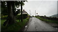
4
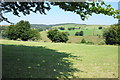
Pasture next to Cefn-crib Road, Pantygasseg
Field is opposite a row of houses. The far side of Cwm y Glyn, partly clear-felled, is in the background.
Image: © M J Roscoe
Taken: 5 Jul 2019
0.06 miles
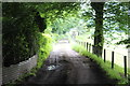
5
Lane behind houses, Pantygasseg
Restricted byway, formerly the route of the Blaen-y-cwm Railroad, below the rear gardens of houses on Cefn Crib Road.
Image: © M J Roscoe
Taken: 3 Jun 2018
0.07 miles
6
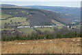
New Houses, Pantygasseg
Hamlet viewed across Cwm y Glyn from Mynydd Llwyd Common. To the right of the row of houses is the green slope of landscaped colliery waste. The woodland behind the houses is on the far side of Cwm Ffrwdoer.
Image: © M J Roscoe
Taken: 20 Mar 2021
0.08 miles
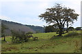
7
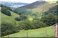
Farmland at Pantygasseg
View across farmland to the north of Pantygasseg.
Image: © Philip Halling
Taken: 10 Aug 2012
0.09 miles
8
Wooded hillside behind New Houses, Pantygasseg
A wooded steep slope viewed from almost the same position as Image
Image: © M J Roscoe
Taken: 14 May 2016
0.10 miles
9
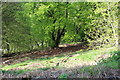
Cwm Ffrwd-oer, Pantygasseg
Valley, now part Tirpentwys local nature reserve, that was formerly involved in coal mining.
Image: © M J Roscoe
Taken: 3 Jun 2018
0.11 miles
10
Lane behind New Houses, Pantygasseg
Lane running behind the gardens of the terraced houses in Pantygasseg.
Image: © M J Roscoe
Taken: 14 May 2016
0.12 miles