IMAGES TAKEN NEAR TO
Primrose Lane, PONTYPOOL, NP4 6TX
Introduction
This page details the photographs taken nearby to Primrose Lane, NP4 6TX by members of the Geograph project.
The Geograph project started in 2005 with the aim of publishing, organising and preserving representative images for every square kilometre of Great Britain, Ireland and the Isle of Man.

There are currently over 7.5m images from over14,400 individuals and you can help contribute to the project by visiting https://www.geograph.org.uk
Image Map
Images are licensed for reuse under creativecommons.org/licenses/by-sa/2.0
Notes
- Clicking on the map will re-center to the selected point.
- The higher the marker number, the further away the image location is from the centre of the postcode.
Image Listing (70 Images Found)
Images are licensed for reuse under creativecommons.org/licenses/by-sa/2.0
Image
Details
Distance
1
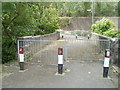
Snatchwood Road signs on the approach to Primrose Lane, Abersychan
No left turn into Primrose Lane.
Image: © Jaggery
Taken: 17 Dec 2015
0.02 miles
2
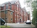
Pontnewynydd Primary School
This side (north) of the school is reached via a long, steep and winding footpath from Lower Leigh Road. Vehicular access is on the southern side. http://www.geograph.org.uk/photo/2412227
Construction of the school began in 1901. It opened in 1903. There are currently about 140 pupils enrolled, aged from 4 to 11.
Image: © Jaggery
Taken: 9 May 2011
0.03 miles
3
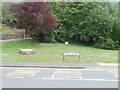
Log bench at Freeholdland Road bus stop, Pontnewynydd
There is no shelter at this bus stop at the northern edge of Freeholdland Road (B4246). Instead, there is a low bench carved out of a tree trunk.
Image: © Jaggery
Taken: 9 May 2011
0.03 miles
4
Junction of Lower Leigh Road and B4246, Pontnewynydd
Lower Leigh Road approaches the B4246, which is named Freeholdland Road to the left and Limekiln Road to the right. Facing the camera is Co-operative Funeralcare, one of about 800 branches of the company in the UK.
Image: © Jaggery
Taken: 9 May 2011
0.04 miles
5
Footbridge across the Afon Lwyd, Pontnewynydd
The width of the bridge suggests this route was formerly open for vehicles, but now only pedestrians or cyclists can pass through the metal barriers. The route leads from the B4246 (opposite the Lower Leigh Road junction) to the A4043.
Image: © Jaggery
Taken: 9 May 2011
0.04 miles
6
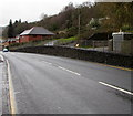
Elevated pavement above Snatchwood Road, Abersychan
For 75 metres, the pavement on the west side of the A4043 Snatchwood Road is above road level.
Image: © Jaggery
Taken: 17 Dec 2015
0.04 miles
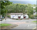
7
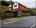
Snatchwood bus stop and shelter opposite Primrose Lane, Abersychan
This stop alongside the A4043 Snatchwood Road is for northbound buses,
towards the centre of Abersychan, and beyond to Blaenavon via Talywain and Varteg.
Image: © Jaggery
Taken: 17 Dec 2015
0.04 miles
8
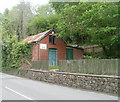
The Old Pump House, Pontnewynydd
Premises of West End Building Contractors, Limekiln Road.
Image: © Jaggery
Taken: 9 May 2011
0.06 miles
9
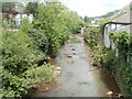
Afon Lwyd flows towards a footbridge, Pontnewynydd
The footbridge http://www.geograph.org.uk/photo/2401531 is a few metres west of the B4246 at the point where the B road's name changes from Limekiln Road to Freeholdland Road, opposite the turning for Lower Leigh Road.
Image: © Jaggery
Taken: 9 May 2011
0.07 miles
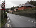
10
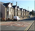
Row of unnumbered houses, Snatchwood Road, Abersychan
Along Snatchwood Road's roughly 600 metre length, many houses are numbered, but many others are not, distinguished only by a name. This occurs in several sections, and on each side of the road, so finding a particular named house can be difficult for visitors. This row of houses are all without house numbers, as are another adjacent row of houses of a different design. http://www.geograph.org.uk/photo/2138618
Image: © Jaggery
Taken: 25 Oct 2010
0.07 miles