IMAGES TAKEN NEAR TO
Pentrepiod, Pontnewynydd, PONTYPOOL, NP4 6TR
Introduction
This page details the photographs taken nearby to NP4 6TR by members of the Geograph project.
The Geograph project started in 2005 with the aim of publishing, organising and preserving representative images for every square kilometre of Great Britain, Ireland and the Isle of Man.

There are currently over 7.5m images from over14,400 individuals and you can help contribute to the project by visiting https://www.geograph.org.uk
Image Map
Images are licensed for reuse under creativecommons.org/licenses/by-sa/2.0
Notes
- Clicking on the map will re-center to the selected point.
- The higher the marker number, the further away the image location is from the centre of the postcode.
Image Listing (8 Images Found)
Images are licensed for reuse under creativecommons.org/licenses/by-sa/2.0
Image
Details
Distance
1
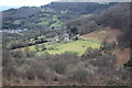
Talocher Farm, Cwm Du
Valley floor viewed from the site of former Llanrch Colliery. The short row of houses in the centre is part of Wesley Terrace Image
Image: © M J Roscoe
Taken: 13 Mar 2018
0.10 miles

3

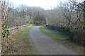
Ty-bwmpyn Lane
This picture was taken from the entrance to the drive to Yew Tree Cottage. It shows how narrow the lane is. The recent heavy rainfall has caused gravel to be washed onto the road.
Image: © Jessica Aidley
Taken: 6 Jul 2007
0.15 miles
4

Ty-bwmpyn Road
A lane between high banks which have had to be well cut back so that there is room for one vehicle at a time.
Image: © Jessica Aidley
Taken: 6 Jul 2007
0.20 miles
5
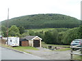
Wooded hillside view from Plasycoed, Pontypool
Houses in the hamlet of Plasycoed are all on the south side of the road, giving good views of the wooded hillsides of Graig Ddu.
Image: © Jaggery
Taken: 26 May 2011
0.23 miles
6
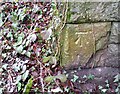
Ordnance Survey Cut Mark
This OS cut mark can be found on the south arch of the viaduct. It marks a point 185.754m above mean sea level.
Image: © Adrian Dust
Taken: 16 Feb 2021
0.24 miles

8
Bridge on former railway over former railway line
Parapets of viaduct, on cycle route on former GWR Monmouthshire Railway, over Nant Ddu and former trackbed of Cwm Nant-Ddu branch line.
Image: © M J Roscoe
Taken: 25 Feb 2022
0.25 miles