IMAGES TAKEN NEAR TO
The Woods, PONTYPOOL, NP4 6RZ
Introduction
This page details the photographs taken nearby to The Woods, NP4 6RZ by members of the Geograph project.
The Geograph project started in 2005 with the aim of publishing, organising and preserving representative images for every square kilometre of Great Britain, Ireland and the Isle of Man.

There are currently over 7.5m images from over14,400 individuals and you can help contribute to the project by visiting https://www.geograph.org.uk
Image Map
Images are licensed for reuse under creativecommons.org/licenses/by-sa/2.0
Notes
- Clicking on the map will re-center to the selected point.
- The higher the marker number, the further away the image location is from the centre of the postcode.
Image Listing (107 Images Found)
Images are licensed for reuse under creativecommons.org/licenses/by-sa/2.0
Image
Details
Distance
1
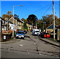
North along Lewis Wood, Charlesville, Torfaen
Near the camera, a sign on the corner of Pentrepiod Road
shows that the road named Lewis Wood leads to Tan-y-coed.
Image: © Jaggery
Taken: 6 Nov 2018
0.02 miles
2
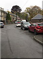
Lewis Wood, Charlesville, Torfaen
From Pentrepiod Road, the road named Lewis Wood leads to Tan-y-coed.
Image: © Jaggery
Taken: 2 Nov 2018
0.02 miles
3
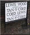
Bilingual name sign on a Charlesville corner, Torfaen
The sign facing Pentrepiod Road shows that Lewis Wood https://www.geograph.org.uk/photo/5966692 leads to Tan-y-coed. The text is also in Welsh.
Image: © Jaggery
Taken: 6 Nov 2018
0.05 miles
4

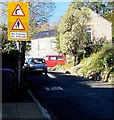
Warning sign - Patrol, Pentrepiod Road, Pentrepiod, Torfaen
Alongside Pentrepiod Road opposite the Chapel Lane junction. The sign text is also in Welsh.
Image: © Jaggery
Taken: 6 Nov 2018
0.05 miles
5
No footway for 200 yards, Pentrepiod Road, Pentrepiod, Torfaen
A bend in the road is ahead.
Image: © Jaggery
Taken: 2 Nov 2018
0.05 miles
6
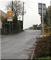
Up Pentrepiod Road, Pentrepiod, Torfaen
Pentrepiod Road west of the Chapel Road junction.
Signs indicate bend to the right ahead and no footway for 200 yards.
Image: © Jaggery
Taken: 6 Nov 2018
0.06 miles
7
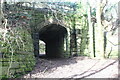
Subway under cycle route, Charlesville
Path from end of narrow lane goes under NCR 492 on former GWR railway. The path turns right Image at the far end of the subway.
Image: © M J Roscoe
Taken: 25 Feb 2022
0.06 miles
8
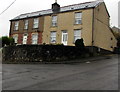
Two semis above a Pentrepiod corner, Torfaen
Semi-detached houses above the corner of Pentrepiod Road and Chapel Road.
Image: © Jaggery
Taken: 6 Nov 2018
0.06 miles
9
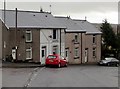
Row of four houses, Pentrepiod Road, Pentrepiod, Torfaen
The Lewis Wood junction is on the left.
Image: © Jaggery
Taken: 6 Nov 2018
0.06 miles
10
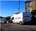
Pure Severn van, Chapel Road, Pontnewynydd
Pure Severn Provisions Ltd is based in Leeway Industrial Estate, Newport. https://www.geograph.org.uk/photo/6026260
Image: © Jaggery
Taken: 2 Nov 2018
0.06 miles