IMAGES TAKEN NEAR TO
Hanbury Road, PONTYPOOL, NP4 6QQ
Introduction
This page details the photographs taken nearby to Hanbury Road, NP4 6QQ by members of the Geograph project.
The Geograph project started in 2005 with the aim of publishing, organising and preserving representative images for every square kilometre of Great Britain, Ireland and the Isle of Man.

There are currently over 7.5m images from over14,400 individuals and you can help contribute to the project by visiting https://www.geograph.org.uk
Image Map
Images are licensed for reuse under creativecommons.org/licenses/by-sa/2.0
Notes
- Clicking on the map will re-center to the selected point.
- The higher the marker number, the further away the image location is from the centre of the postcode.
Image Listing (145 Images Found)
Images are licensed for reuse under creativecommons.org/licenses/by-sa/2.0
Image
Details
Distance
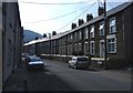
3
Coronation Terrace, Hanbury Road, Pontnewynydd
Each row of houses along this section of the road is separately named. This row, to the west of the Mountain View Road http://www.geograph.org.uk/photo/2441153 turning, is Coronation Terrace.
Image: © Jaggery
Taken: 26 May 2011
0.03 miles
4
Coronation Terrace, Hanbury Road, Pontnewynydd
Looking along Coronation Terrace towards the corner of Mountain View Road.
This is one of several separately-named rows of houses in Hanbury Road.
Image: © Jaggery
Taken: 1 Sep 2016
0.04 miles
5
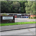
Outdated name sign, Pontnewynydd Small Business Centre
In early September 2016, the sign shows GWENT COUNTY COUNCIL, which was abolished in April 1996. Pontnewynydd is now in the county borough of Torfaen. An up-to-date name sign is nearby. http://www.geograph.org.uk/photo/5101198
Image: © Jaggery
Taken: 1 Sep 2016
0.04 miles
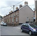
6
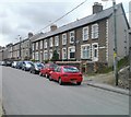
Pleasant View, Hanbury Road, Pontypool
Each row of houses along this section of the road is separately named. This row of five houses is named Pleasant View.
Image: © Jaggery
Taken: 26 May 2011
0.04 miles
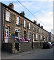
7
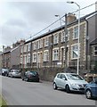
Bailey's Terrace, Hanbury Road, Pontypool
Each row of houses along this section of the road is separately named. This row is Bailey's Terrace.
Image: © Jaggery
Taken: 26 May 2011
0.04 miles
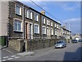
8
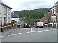
View from the top of Mountain View Road, Pontypool
The view south from the corner of School Road.
Image: © Jaggery
Taken: 26 May 2011
0.04 miles
9
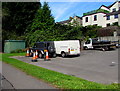
Estate Road electricity substation, Pontnewynydd
The green cabinet is a Western Power Distribution electricity substation, identifier S/S No 532628,
located at the western edge of the parking area near Forge Row. http://www.geograph.org.uk/photo/5101116
Image: © Jaggery
Taken: 1 Sep 2016
0.05 miles
10
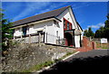
Ebenezer Centre, Cwmffrwdoer above Pontnewynydd
Set back 50 metres above the north side of Hanbury Road. The former Sunday School building has been converted to a multipurpose community centre with 21st century facilities.
Image: © Jaggery
Taken: 1 Sep 2016
0.05 miles