IMAGES TAKEN NEAR TO
Tirpentwys Terrace, PONTYPOOL, NP4 6QL
Introduction
This page details the photographs taken nearby to Tirpentwys Terrace, NP4 6QL by members of the Geograph project.
The Geograph project started in 2005 with the aim of publishing, organising and preserving representative images for every square kilometre of Great Britain, Ireland and the Isle of Man.

There are currently over 7.5m images from over14,400 individuals and you can help contribute to the project by visiting https://www.geograph.org.uk
Image Map
Images are licensed for reuse under creativecommons.org/licenses/by-sa/2.0
Notes
- Clicking on the map will re-center to the selected point.
- The higher the marker number, the further away the image location is from the centre of the postcode.
Image Listing (85 Images Found)
Images are licensed for reuse under creativecommons.org/licenses/by-sa/2.0
Image
Details
Distance
1
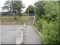
Steps up to a path to Waunddu, Pontypool
The steps connect the edge of Church Road with a path http://www.geograph.org.uk/photo/2441231 to Waunddu.
Image: © Jaggery
Taken: 26 May 2011
0.02 miles
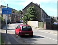
2
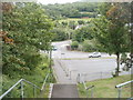
View SE from a path from Waunddu, Pontypool
The view SE from the top of steps http://www.geograph.org.uk/photo/2441234 at the edge of a path http://www.geograph.org.uk/photo/2441231 from Waunddu.
The road in the middle distance, behind the car facing the camera, is Plasycoed Road.
Image: © Jaggery
Taken: 26 May 2011
0.02 miles
3
Path on the west side of Chapel Road, Pontypool
The path heads north towards the south side of a road named Waunddu.
Image: © Jaggery
Taken: 26 May 2011
0.02 miles
4
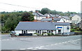
Bridgend Inn, Pontnewynydd, Pontypool
Located on the corner of Hanbury Road and Chapel Road.
Image: © Jaggery
Taken: 26 May 2011
0.02 miles
5
Cyclists rejoin carriageway sign, Plasycoed Road, Pontnewynydd
Facing the end of a cycle route southwest of the Estate Road, Hanbury Road and Chapel Road crossroads.
Image: © Jaggery
Taken: 1 Sep 2016
0.04 miles
6
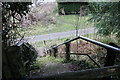
Steps down to National Cycle Route 492
Steep, somewhat overgrown, flight of concrete steps from stile at edge of field to a metal bridge to cycle path on former railway track bed. The public footpath continues across the cycle route.
Image: © M J Roscoe
Taken: 10 Jan 2019
0.04 miles
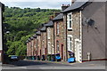
7
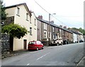
Plasycoed Road, Pontypool
Houses on the south side of the road, near the eastern end of Plasycoed Road.
Image: © Jaggery
Taken: 26 May 2011
0.04 miles
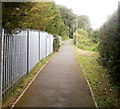
8
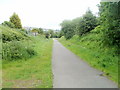
Path and cycleway to the south of Plasycoed Road, Pontypool
The path uses the route of a long-dismantled railway line.
Image: © Jaggery
Taken: 26 May 2011
0.04 miles
9
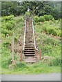
Steps up from a footpath and cycleway, Pontypool
The path and cycleway use the route of a long since dismantled railway line to
the south of Plasycoed Road. The long flight of steps lead up to a field. http://www.geograph.org.uk/photo/2442188
Image: © Jaggery
Taken: 26 May 2011
0.04 miles
10
Kitchener Street
The eastern side of a cul-de-sac off Plasycoed Road; dustbins and recycling boxes are out ready for the contents to be collected.
Image: © M J Roscoe
Taken: 13 Jun 2017
0.04 miles