IMAGES TAKEN NEAR TO
Plasycoed Road, PONTYPOOL, NP4 6QH
Introduction
This page details the photographs taken nearby to Plasycoed Road, NP4 6QH by members of the Geograph project.
The Geograph project started in 2005 with the aim of publishing, organising and preserving representative images for every square kilometre of Great Britain, Ireland and the Isle of Man.

There are currently over 7.5m images from over14,400 individuals and you can help contribute to the project by visiting https://www.geograph.org.uk
Image Map
Images are licensed for reuse under creativecommons.org/licenses/by-sa/2.0
Notes
- Clicking on the map will re-center to the selected point.
- The higher the marker number, the further away the image location is from the centre of the postcode.
Image Listing (35 Images Found)
Images are licensed for reuse under creativecommons.org/licenses/by-sa/2.0
Image
Details
Distance
1
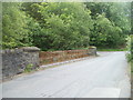
Lockup garages and wooded hillside, Plasycoed, Pontypool
Looking past lockup garages at the SE edge of the hamlet of Plasycoed, towards a wooded hillside (Graig Ddu).
Image: © Jaggery
Taken: 26 May 2011
0.05 miles
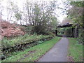
2
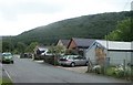
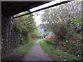
Plasycoed Road bridge, Pontypool
The bridge carries Plasycoed Road over a path and cycleway. This was formerly the route of a railway, long since dismantled.
Image: © Jaggery
Taken: 26 May 2011
0.05 miles
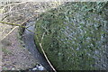
3
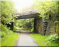
Pontypool : Plasycoed Road crosses over a former railway line
The rusted metal meshing is on a bridge http://www.geograph.org.uk/photo/2442151 carrying Plasycoed Road over a footpath and cycleway, formerly a railway line.
Image: © Jaggery
Taken: 26 May 2011
0.05 miles
4
Site of former Cwmffrwdoer Halt on NCN Route 46
Image: © Gareth James
Taken: 15 Oct 2011
0.05 miles
5
Nant Ffrwd-oer
Looking downstream from the end of the former railway bridge.
Image: © M J Roscoe
Taken: 25 Feb 2022
0.07 miles
6
Site of former Cwmffrwdoer Halt on NCN Route 46
Image: © Gareth James
Taken: 15 Oct 2011
0.07 miles
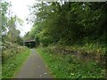
8

NCN492 on old railway line
On each side there are what appear to be platforms; no station is marked on the old maps, but a brickworks was close to the line
Image: © David Smith
Taken: 26 Sep 2021
0.08 miles
9
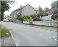
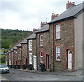
Plasycoed Road houses, Pontypool
Houses on the south side of the road in the hamlet of Plasycoed, SW Pontypool.
Image: © Jaggery
Taken: 26 May 2011
0.09 miles
10
Buller Street,Pontypool
Houses on the east side of the street, viewed from Plasycoed Road. Buller Street is one of two short cul-de-sacs side-by-side on the north side of Plasycoed Road.
The other one is Kitchener Street. http://www.geograph.org.uk/photo/2441266
Image: © Jaggery
Taken: 26 May 2011
0.09 miles