IMAGES TAKEN NEAR TO
Park Road, PONTYPOOL, NP4 6NZ
Introduction
This page details the photographs taken nearby to Park Road, NP4 6NZ by members of the Geograph project.
The Geograph project started in 2005 with the aim of publishing, organising and preserving representative images for every square kilometre of Great Britain, Ireland and the Isle of Man.

There are currently over 7.5m images from over14,400 individuals and you can help contribute to the project by visiting https://www.geograph.org.uk
Image Map
Images are licensed for reuse under creativecommons.org/licenses/by-sa/2.0
Notes
- Clicking on the map will re-center to the selected point.
- The higher the marker number, the further away the image location is from the centre of the postcode.
Image Listing (473 Images Found)
Images are licensed for reuse under creativecommons.org/licenses/by-sa/2.0
Image
Details
Distance
1
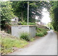
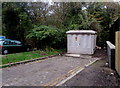
Gas box, Church Wood, Pontypool
The box is located on the side of Church Wood, http://www.geograph.org.uk/photo/2429706 a cul-de-sac on the west side of Park Road.
A notice on the road side of the box shows an 0800 phone number to ring before beginning any work on, or within 10 metres of, the box, or in an emergency.
Image: © Jaggery
Taken: 27 May 2011
0.02 miles
2
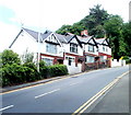
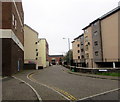
Four houses on a bend in Park Road, Pontypool
Just beyond the house at the far end, the road bends through 90 degrees.
Image: © Jaggery
Taken: 27 May 2011
0.02 miles
3
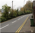
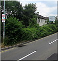
No parking on Park Road, Pontypool
Double yellow lines on both sides of the road make parking here illegal at any time.
Vegetation covers a part of the Welcome Penygarn sign.
Image: © Jaggery
Taken: 3 Nov 2015
0.03 miles
4
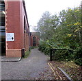
Side road beyond Forge Lane, Pontypool
The road between Riverside multistorey car park http://www.geograph.org.uk/photo/4730071 and a river,
the Afon Lwyd, is for medical centre emergency & delivery vehicles only.
Image: © Jaggery
Taken: 3 Nov 2015
0.03 miles
5
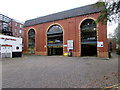
Riverside multistorey car park, Pontypool
Viewed across Forge Lane. Entrance on centre left, exit on the right.
In November 2015, the free car park is open from 7am - 9.15pm (Mondays to Saturdays)
and 9am – 5.30pm on Sundays. There are 18 parking spaces for Blue Badge Holders.
Image: © Jaggery
Taken: 3 Nov 2015
0.03 miles
6
Forge Lane, Pontypool
Extending for 100 metres from the corner of Park Road to Riverside multistorey car park. http://www.geograph.org.uk/photo/4730071
Image: © Jaggery
Taken: 3 Nov 2015
0.03 miles
7
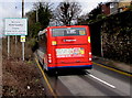
Stagecoach bus enters Penygarn, Pontypool
Heading north on Park Road, Stagecoach bus number 47305 is on bus route 15 from Newport to Trevethin.
Image: © Jaggery
Taken: 15 Mar 2018
0.04 miles
8
Pontypool Town electricity substation
Set back from the east side of Forge Lane, on a bank of a river, the Afon Lwyd.
The Western Power Distribution electricity substation identifier is PONTYPOOL TOWN S/S 53-6753.
Image: © Jaggery
Taken: 3 Nov 2015
0.04 miles
9
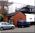
Willpower Weightlifting Club, Forge Lane, Pontypool
Located in the single-storey brick building.
Image: © Jaggery
Taken: 3 Nov 2015
0.04 miles
10
Two signs alongside Park Road, Pontypool
A Cold Calling Control Zone sign is on the left. A sign showing Welcome
to Penygarn - Please drive carefully is on the right. The text is also in Welsh.
Image: © Jaggery
Taken: 16 Jul 2018
0.04 miles