IMAGES TAKEN NEAR TO
Lewis Terrace, PONTYPOOL, NP4 6NY
Introduction
This page details the photographs taken nearby to Lewis Terrace, NP4 6NY by members of the Geograph project.
The Geograph project started in 2005 with the aim of publishing, organising and preserving representative images for every square kilometre of Great Britain, Ireland and the Isle of Man.

There are currently over 7.5m images from over14,400 individuals and you can help contribute to the project by visiting https://www.geograph.org.uk
Image Map
Images are licensed for reuse under creativecommons.org/licenses/by-sa/2.0
Notes
- Clicking on the map will re-center to the selected point.
- The higher the marker number, the further away the image location is from the centre of the postcode.
Image Listing (188 Images Found)
Images are licensed for reuse under creativecommons.org/licenses/by-sa/2.0
Image
Details
Distance
1
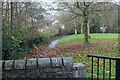
Riverside path, Pontnewynydd Park, Pontypool
The river, the Afon Lwyd, is to the left of the overgrown railings.
Image: © M J Roscoe
Taken: 19 Nov 2020
0.01 miles
2
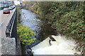
Afon Lwyd by Mill Road, Pontnewynydd
Looking upstream across small weir.
Image: © M J Roscoe
Taken: 19 Nov 2020
0.01 miles
3
Leigh Road above Hospital Road, Pontnewynydd
Looking up from Pontnewynydd Park across Hospital Road to Leigh Road, with part of Pontnewynydd Social Club on the right.
Image: © M J Roscoe
Taken: 19 Nov 2020
0.02 miles
4
Entrance arch to a former outdoor swimming pool, Pontnewynydd
Viewed across the Afon Lwyd from Mill Road. The inscription on the arch is
1915 AUDC SWIMMING BATHS. (AUDC = Abersychan Urban District Council).
There was formerly a footbridge across the river here which led into open-air swimming baths.
The baths were in use until the 1980s, whereafter the site was filled in and grassed over.
All that remains is this partly-overgrown entrance arch.
Image: © Jaggery
Taken: 23 Sep 2011
0.02 miles
5

Defunct gateway, Pontnewynydd Park
This brick and concrete gateway, once served by a bridge across the Afon Lwyd from Mill Road, was a pedestrian entrance to the former swimming baths. For an earlier view of the Mill Road side of the gateway - Image
Image: © M J Roscoe
Taken: 19 Nov 2020
0.02 miles
6

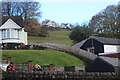
Entrance to Pontnewydd Park
Community Links cycle and pedestrian path from Hospital Road into riverside park. At one time in the last century there was a swimming bath in the park. The white building beyond is Fairview Court.
Image: © M J Roscoe
Taken: 19 Nov 2020
0.03 miles
7
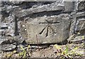
Ordnance Survey Cut Mark
This OS cut mark can be found on the west parapet of Pont Newynydd. It marks a point 138.395m above mean sea level.
Image: © Adrian Dust
Taken: 7 Jul 2019
0.03 miles
8
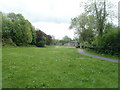
Riverside recreation area, Pontnewynydd
The view SE towards Mill Road houses along a long, narrow recreation area on the east bank of the Afon Lwyd river.
Image: © Jaggery
Taken: 10 May 2011
0.03 miles
9
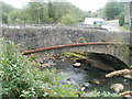
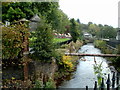
Grade II listed river bridge, Pontnewynydd
The surrounding area of Pontnewynydd, is named for this stone bridge, Pont Newynydd, which crosses the Afon Lwyd from Hospital Road to Mill Road. It was grade II listed in 1997.
Image: © Jaggery
Taken: 10 May 2011
0.03 miles
10
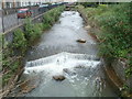
Small weir, Afon Lwyd, Pontnewynydd
The view west along the Afon Lwyd from a Grade II listed stone bridge. http://www.geograph.org.uk/photo/2425020
Mill Road is on the left.
Image: © Jaggery
Taken: 10 May 2011
0.03 miles