IMAGES TAKEN NEAR TO
Merchants Hill Close, PONTYPOOL, NP4 6NU
Introduction
This page details the photographs taken nearby to Merchants Hill Close, NP4 6NU by members of the Geograph project.
The Geograph project started in 2005 with the aim of publishing, organising and preserving representative images for every square kilometre of Great Britain, Ireland and the Isle of Man.

There are currently over 7.5m images from over14,400 individuals and you can help contribute to the project by visiting https://www.geograph.org.uk
Image Map
Images are licensed for reuse under creativecommons.org/licenses/by-sa/2.0
Notes
- Clicking on the map will re-center to the selected point.
- The higher the marker number, the further away the image location is from the centre of the postcode.
Image Listing (193 Images Found)
Images are licensed for reuse under creativecommons.org/licenses/by-sa/2.0
Image
Details
Distance
1
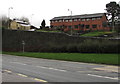
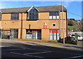
Modern houses, Merchants Hill, Pontnewynydd
Above the A4043 Osborne Road.
Image: © Jaggery
Taken: 17 Dec 2015
0.01 miles
3
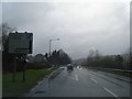
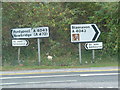
Warning sign - staggered crossroads ahead, Pontnewynydd
Facing the A4043 Osborne Road, the red-edged triangular sign is on the approach to the junction
of Merchants Hill on the left and George Street, about 50 metres further along, on the right.
Image: © Jaggery
Taken: 17 Dec 2015
0.02 miles
4
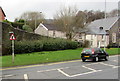
Row of houses, Merchants Hill, Pontnewynydd
The row is between Merchants Hill Baptist Church http://www.geograph.org.uk/photo/4767248 and Merchants Hill Close.
Image: © Jaggery
Taken: 17 Dec 2015
0.02 miles
5
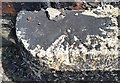
Ordnance Survey Rivet
This OS rivet can be found on the NE parapet of the bridge on Merchants Hill. It marks a point 150.254m above mean sea level.
Image: © Adrian Dust
Taken: 7 Jul 2019
0.02 miles
6
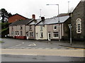
Pavilion Service Station, Pontnewynydd, Pontypool
On the corner of Osborne Road and Hospital Road, Pavilion Service Station
contains a Texaco filling station and a Londis shop.
Image: © Jaggery
Taken: 2 Jan 2014
0.03 miles
7
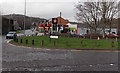
Boxing Gym bus stop and shelter, Pontnewynydd
On the north side of the A4043 Osborne Road, this stop is for buses towards Pontypool,
Cwmbran and Newport. Pontypool Boxing Club's boxing gym is in the background.
Image: © Jaggery
Taken: 17 Dec 2015
0.03 miles
8
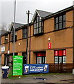
A small branch of St. John Ambulance
Clearly must be a very small branch of St. John Ambulance ... careful not to call them St. John's as they get awfully upset!
Image: © Nick Mutton 01329 000000
Taken: 16 Sep 2007
0.03 miles
9
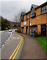
Legacy Gym, Osborne Road, Pontnewynydd
Viewed across the A4043 Osborne Road in November 2018.
Text in view shows that Legacy Gym is open 7 days a week.
Gym fees are from £25 per month.
Beau Bronze Tanning Studio is at the rear of the building.
The bus stop on the left is for buses to Pontypool town centre, Cwmbran, Newport etc.
Image: © Jaggery
Taken: 2 Nov 2018
0.03 miles
10
100% arabica freshly ground coffee banner, Pavilion Garage, Pontnewynydd
The banner is alongside a Welcome to your Local Londis board.
The Londis is behind the fuel pumps here. http://www.geograph.org.uk/photo/4767265
Pontypool Boxing Club's boxing gym is in the background.
Image: © Jaggery
Taken: 17 Dec 2015
0.03 miles