IMAGES TAKEN NEAR TO
Pavilion Industrial Estate, PONTYPOOL, NP4 6NF
Introduction
This page details the photographs taken nearby to Pavilion Industrial Estate, NP4 6NF by members of the Geograph project.
The Geograph project started in 2005 with the aim of publishing, organising and preserving representative images for every square kilometre of Great Britain, Ireland and the Isle of Man.

There are currently over 7.5m images from over14,400 individuals and you can help contribute to the project by visiting https://www.geograph.org.uk
Image Map
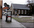
Images are licensed for reuse under creativecommons.org/licenses/by-sa/2.0
Notes
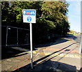
- Clicking on the map will re-center to the selected point.
- The higher the marker number, the further away the image location is from the centre of the postcode.
Image Listing (216 Images Found)
Images are licensed for reuse under creativecommons.org/licenses/by-sa/2.0
Image
Details
Distance
1
BT phonebox, George Street, Pontnewynydd
Near the southern end of George Street, on the approach to the A4043 Osborne Road.
Image: © Jaggery
Taken: 17 Dec 2015
0.01 miles
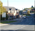
2
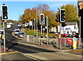
Twin pelican crossings, Osborne Road, Pontnewynydd
Two separately-controlled pelican crossings, with a central refuge, across the A4043 Osborne Road.
Chambers Dictionary states that "pelican" in this context is adapted from "pedestrian light controlled crossing".
Image: © Jaggery
Taken: 2 Nov 2018
0.01 miles
3
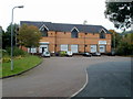
Units 1-3, Pavilion Industrial Estate, Pontnewynydd
This is the western side of a small industrial estate between Mill Road and Osborne Road.
The name on unit 1 (on the right) is Pentwyn Splicers.
Image: © Jaggery
Taken: 23 Sep 2011
0.01 miles
4
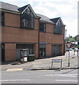
BT phonebox and telecoms cabinet on a Pontnewynydd corner
On the corner of the B4246 George Street and the A4043 Osborne Road.
The bilingual name sign shows that George Street is Stryd Siôr in Welsh.
Image: © Jaggery
Taken: 1 Sep 2016
0.02 miles
5
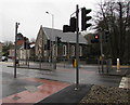
Osborne Road pelican crossing, Pontnewynydd
Across the A4043 Osborne Road to Merchants Hill Baptist Church. http://www.geograph.org.uk/photo/4767248
Chambers Dictionary states that "pelican" is adapted from "pedestrian light controlled crossing".
Image: © Jaggery
Taken: 17 Dec 2015
0.02 miles
6
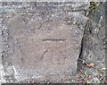
Ordnance Survey Cut Mark
This OS cut mark can be found on the SW parapet of the bridge, Osborne Road. It marks a point 140.013m above mean sea level.
Image: © Adrian Dust
Taken: 7 Jul 2019
0.02 miles
7
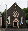
Baptist Chapel on Merchants Hill, Pontneynydd
Image: © Ian S
Taken: 24 May 2014
0.03 miles
8
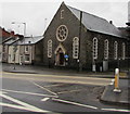
Merchants Hill Baptist Church, Pontnewynydd
Viewed across the A4043 Osborne Road. The inscription above the doorway is BAPTIST CHAPEL 1888.
In 2015, the church is a member of the South Wales Baptist Association, part of the Baptist Union of Great Britain.
Image: © Jaggery
Taken: 17 Dec 2015
0.03 miles
9
Cycle route 492 direction sign alongside the A4043, Pontnewynydd
National Cycle Network Route 492 extends from Cwmbran towards Brynmawr via Blaenavon.
Image: © Jaggery
Taken: 2 Nov 2018
0.03 miles
10
Welcome to Pontypool
A bilingual (English and Welsh) sign on Osborne Road (A4043) welcomes you to the NW edge of Pontypool, and states that the town is twinned with three towns, but does not show the relevant countries. The Torfaen County Borough website has this :
"Pontypool is twinned with three towns in Europe: Longjumeau in France since 1994, Bretten in Germany since 1994 and Condeixa in Portugal since 1999. Uniquely each of these towns is twinned with each other and annual conferences are held to discuss issues pertinent to all 4 towns"
Image: © Jaggery
Taken: 25 Oct 2010
0.03 miles