IMAGES TAKEN NEAR TO
Merchants Hill, PONTYPOOL, NP4 6NE
Introduction
This page details the photographs taken nearby to Merchants Hill, NP4 6NE by members of the Geograph project.
The Geograph project started in 2005 with the aim of publishing, organising and preserving representative images for every square kilometre of Great Britain, Ireland and the Isle of Man.

There are currently over 7.5m images from over14,400 individuals and you can help contribute to the project by visiting https://www.geograph.org.uk
Image Map
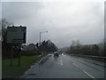
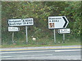
Images are licensed for reuse under creativecommons.org/licenses/by-sa/2.0
Notes
- Clicking on the map will re-center to the selected point.
- The higher the marker number, the further away the image location is from the centre of the postcode.
Image Listing (205 Images Found)
Images are licensed for reuse under creativecommons.org/licenses/by-sa/2.0
Image
Details
Distance
1
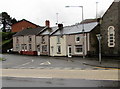
Row of houses, Merchants Hill, Pontnewynydd
The row is between Merchants Hill Baptist Church http://www.geograph.org.uk/photo/4767248 and Merchants Hill Close.
Image: © Jaggery
Taken: 17 Dec 2015
0.01 miles
2
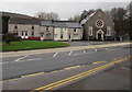
Merchants Hill houses and church, Pontnewynydd
Viewed across the A4043 Osborne Road. The church is Merchants Hill Baptist Church. http://www.geograph.org.uk/photo/4767248
Image: © Jaggery
Taken: 17 Dec 2015
0.01 miles
3
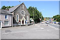
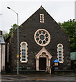
Merchant's Hill Baptist Chapel
The inscription above Merchant's Hill Baptist Chapel dates it to 1888. The A4043 is the road on the right.
Image: © Philip Halling
Taken: 10 Aug 2012
0.01 miles
4
A small branch of St. John Ambulance
Clearly must be a very small branch of St. John Ambulance ... careful not to call them St. John's as they get awfully upset!
Image: © Nick Mutton 01329 000000
Taken: 16 Sep 2007
0.01 miles
5
Baptist Chapel on Merchants Hill, Pontneynydd
Image: © Ian S
Taken: 24 May 2014
0.02 miles
6
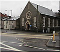
Merchants Hill Baptist Church, Pontnewynydd
Viewed across the A4043 Osborne Road. The inscription above the doorway is BAPTIST CHAPEL 1888.
In 2015, the church is a member of the South Wales Baptist Association, part of the Baptist Union of Great Britain.
Image: © Jaggery
Taken: 17 Dec 2015
0.02 miles
7
Cycle route 492 direction sign alongside the A4043, Pontnewynydd
National Cycle Network Route 492 extends from Cwmbran towards Brynmawr via Blaenavon.
Image: © Jaggery
Taken: 2 Nov 2018
0.02 miles
8
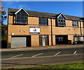
Boxing Gym, Osborne Road, Pontnewynydd
Viewed across the A4043 Osborne Road in November 2018.
The nameboard shows BOXING GYM - PONTYPOOL AMATEUR BOXING CLUB.
Image: © Jaggery
Taken: 2 Nov 2018
0.02 miles
9
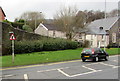
Warning sign - staggered crossroads ahead, Pontnewynydd
Facing the A4043 Osborne Road, the red-edged triangular sign is on the approach to the junction
of Merchants Hill on the left and George Street, about 50 metres further along, on the right.
Image: © Jaggery
Taken: 17 Dec 2015
0.02 miles