1
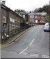
Up St James Field, Pontypool
The road named St James Field in English is Cae Sant Iago in Welsh.
St James Hall https://www.geograph.org.uk/photo/6336953 is on the left.
Image: © Jaggery
Taken: 5 Dec 2019
0.01 miles
2
Former ambulance station, St James' Field, Pontypool
Image: © John Lord
Taken: 2 Mar 2011
0.01 miles
3
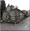
Steep ascent in Pontypool
The road named St James Field (Cae Sant Iago in Welsh) https://www.geograph.org.uk/photo/6657018 ascends from Hanbury Road.
Image: © Jaggery
Taken: 26 Jul 2020
0.01 miles
4
Seedtime & Harvest Church
The Seedtime & Harvest Church in Hanbury Street. This church has another branch in Redruth, Cornwall.
Image: © David Roberts
Taken: 27 Jul 2008
0.02 miles
5
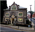
Grade II listed St James church hall, Pontypool
The Edwardian church hall (c1910) was Grade II listed in 1997.
The CCTV camera is on the corner of Hanbury Road and St James Field.
Image: © Jaggery
Taken: 5 Dec 2016
0.02 miles
6
Ysgol Feithrin Pontypwl, St James Hall, Pontypool
Ysgol Feithrin Pontypwl is Welsh for Pontypool Nursery School.
Image: © Jaggery
Taken: 5 Dec 2019
0.02 miles
7
Grade II listed St James Vicarage, Pontypool
Set back from Hanbury Road, the building dating from 1923 has a hipped roof with two tall stone chimney stacks. St James Vicarage was Grade II listed in 1997.
Image: © Jaggery
Taken: 5 Dec 2016
0.03 miles
8
Zebra crossing and 5mph speed limit, Pontypool
This is the exit road from Top Car Park and a Tesco superstore. http://www.geograph.org.uk/photo/4328541
Image: © Jaggery
Taken: 27 Jan 2015
0.03 miles
9
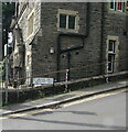
Bilingual name sign on a Pontypool corner
The sign shows that the road named St James Field is Cae Sant Iago in Welsh.
Image: © Jaggery
Taken: 26 Jul 2020
0.03 miles
10
Temporary library, Pontypool
Image: © John Lord
Taken: 2 Mar 2011
0.03 miles


