IMAGES TAKEN NEAR TO
Davis Close, PONTYPOOL, NP4 6GP
Introduction
This page details the photographs taken nearby to Davis Close, NP4 6GP by members of the Geograph project.
The Geograph project started in 2005 with the aim of publishing, organising and preserving representative images for every square kilometre of Great Britain, Ireland and the Isle of Man.

There are currently over 7.5m images from over14,400 individuals and you can help contribute to the project by visiting https://www.geograph.org.uk
Image Map
Images are licensed for reuse under creativecommons.org/licenses/by-sa/2.0
Notes
- Clicking on the map will re-center to the selected point.
- The higher the marker number, the further away the image location is from the centre of the postcode.
Image Listing (160 Images Found)
Images are licensed for reuse under creativecommons.org/licenses/by-sa/2.0
Image
Details
Distance
1
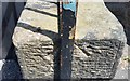
Ordnance Survey Rivet
This OS rivet can be found on the wall of No74 Osborne Road. It marks a point 136.938m above mean sea level.
Image: © Adrian Dust
Taken: 7 Jul 2019
0.07 miles
2
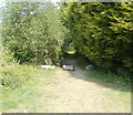
Track into woods from Riverside, Pontypool
Boulders block vehicular access to a track along the eastern bank of the Afon Lwyd, into woodland. Viewed from the edge of a road named Riverside.
Image: © Jaggery
Taken: 4 May 2011
0.07 miles
3
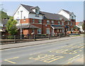
Afon Lwyd Close, Pontypool
Modern housing viewed across the main road, Riverside.
Image: © Jaggery
Taken: 4 May 2011
0.07 miles
4
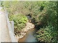
Afon Lwyd upstream from Riverside, Pontypool
The Afon Lwyd flows towards the bridge carrying a main road, Riverside, over the river.
Image: © Jaggery
Taken: 4 May 2011
0.07 miles
5
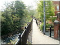
Riverside walk, Pontypool
The path is between the Afon Lwyd river and Afon Lwyd Close.
Image: © Jaggery
Taken: 4 May 2011
0.07 miles
6

Ten letterboxes, Griffin Court, Osborne Road, Pontypool
The door is here. http://www.geograph.org.uk/photo/2394825 The postman needs to concentrate here - odd-numbered flats on the left,
lowest number at the top, even-numbered on the right, highest number at the top.
Image: © Jaggery
Taken: 2 Jan 2014
0.07 miles
7
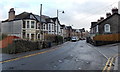
Osborne Road, Pontypool
Viewed from near the Malthouse Lane junction (on the right) looking towards Griffin Court. http://www.geograph.org.uk/photo/2394825
Image: © Jaggery
Taken: 2 Jan 2014
0.07 miles
8
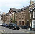
Griffin Court, Pontypool
The former Griffin Press building on Osborne Road has been converted to 15 flats.
Image: © Jaggery
Taken: 4 May 2011
0.07 miles
9
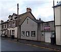
Sharon Full Gospel Church, Pontypool
Sharon Full Gospel Church began with a Gospel mission in a tent in Pontypool Park in 1936.
Later, the church used Emmanuel Hall (now the Pontypool Salvation Army citadel) http://www.geograph.org.uk/photo/1853971
The church has been here in Osborne Road since 1952.
Image: © Jaggery
Taken: 2 Jan 2014
0.07 miles
10
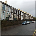
Long row of houses, Osborne Road, Pontypool
Looking NNW towards Pontnewynydd.
Image: © Jaggery
Taken: 2 Jan 2014
0.08 miles