1
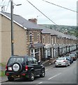
Wainfelin Avenue, Pontypool
Houses on the north side of the street, viewed from the corner of Penywain Road.
Image: © Jaggery
Taken: 16 May 2011
0.03 miles
2
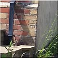
Ordnance Survey Cut Mark
This OS cut mark can be found on the NE angle of the old Post Office which is now No1 Pennywain Road. It marks a point 187.830m above mean sea level.
Image: © Adrian Dust
Taken: 7 Jul 2019
0.05 miles
3
One side only parking, Wainfelin Avenue, Pontypool
There are no double yellow lines to prevent parking, so it must be
a local custom to park vehicles on only one side of Wainfelin Avenue.
Image: © Jaggery
Taken: 23 Sep 2011
0.05 miles
4
St John the Divine, Pontypool
Reroofing is in progress on the Church in Wales church located on the corner of Penywain Road and St John's Close, Wainfelin, Pontypool.
Image: © Jaggery
Taken: 16 May 2011
0.07 miles
5
Helpstone Terrace houses, Pontypool
Located in the Wainfelin district of Pontypool, viewed across Penywain Road.
Image: © Jaggery
Taken: 16 May 2011
0.08 miles
6
Penywain Terrace, Pontypool
Houses on the south side of the street, viewed from the corner of Penywain Road.
Image: © Jaggery
Taken: 16 May 2011
0.11 miles
7
Ordnance Survey Cut Mark
This OS cut mark can be found on No60 Wainfelin Avenue. It marks a point 177.132m above mean sea level.
Image: © Adrian Dust
Taken: 7 Jul 2019
0.11 miles
8
Looking towards Tranch Wood from the edge of Fowler Street, Pontypool
Image: © Jaggery
Taken: 10 May 2011
0.11 miles
9
Fowler Street, Wainfelin, Pontypool
Houses on the north side of the street viewed from the western end of Wainfelin Road.
Image: © Jaggery
Taken: 10 May 2011
0.12 miles
10
Cycle route, footpath and bridleway, Wainfelin, Pontypool
Viewed across Elled Road, about 50 metres south of the Little Crown Inn. http://www.geograph.org.uk/photo/2425452
The sign indicates that the path is a footpath, bridleway and cycle route (part of National Cycle Network route 492).
Image: © Jaggery
Taken: 10 May 2011
0.12 miles


