IMAGES TAKEN NEAR TO
Wainfelin Road, PONTYPOOL, NP4 6DL
Introduction
This page details the photographs taken nearby to Wainfelin Road, NP4 6DL by members of the Geograph project.
The Geograph project started in 2005 with the aim of publishing, organising and preserving representative images for every square kilometre of Great Britain, Ireland and the Isle of Man.

There are currently over 7.5m images from over14,400 individuals and you can help contribute to the project by visiting https://www.geograph.org.uk
Image Map
Images are licensed for reuse under creativecommons.org/licenses/by-sa/2.0
Notes
- Clicking on the map will re-center to the selected point.
- The higher the marker number, the further away the image location is from the centre of the postcode.
Image Listing (114 Images Found)
Images are licensed for reuse under creativecommons.org/licenses/by-sa/2.0
Image
Details
Distance
1
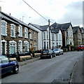
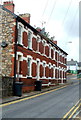
Change of house type, Wainfelin Road, Pontypool
There are rows of houses on the camera side. Further ahead are larger, semi-detached, houses.
Image: © Jaggery
Taken: 23 Sep 2011
0.04 miles
2
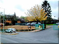
George Street Primary and Nursery School, Pontypool
The school is in the Wainfelin district of Pontypool.
Image: © Jaggery
Taken: 23 Sep 2011
0.05 miles
3
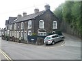
Former Herbert Terrace, Pontypool
A stone inscription on this row of houses on Osborne Road shows Herbert Terrace 1884, but the houses are now numbered in the Osborne Road sequence and the name sign near the car shows Osborne Road.
Image: © Jaggery
Taken: 4 May 2011
0.06 miles
4
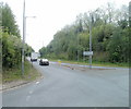
A4043 heads into Pontypool from Riverside Roundabout
Viewed from opposite the sculpture http://www.geograph.org.uk/photo/2395265 on the roundabout.
Image: © Jaggery
Taken: 4 May 2011
0.06 miles
5
Amberley Place, Pontypool
Amberley Place is a separately-named row of 4 houses in George Street,
opposite Pontypool Ambulance Station. http://www.geograph.org.uk/photo/3369971
Image: © Jaggery
Taken: 23 Sep 2011
0.06 miles
6
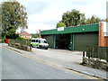
Pontypool Ambulance Station
Viewed across George Street. The name sign shows that this site is part of the Welsh Ambulance Services NHS Trust.
Image: © Jaggery
Taken: 23 Sep 2011
0.06 miles
7
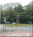
Tower sculpture, Pontypool
Located in the middle of Riverside Roundabout at the junction of the A4043 and Riverside.
This is one of three artworks created by sculptor Robert Kennedy based on ideas contributed by young people in Torfaen. Named 'The Tower, the sculpture has a Welsh slate base topped with a block of Portland stone hand carved in a flame pattern. The dark colouring represents the heavy industry that formerly occupied the valley from here to Blaenavon. The flame pattern suggests furnaces, and also the flame of ideas.
Image: © Jaggery
Taken: 4 May 2011
0.08 miles
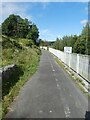
9
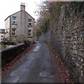
Northern end of Malthouse Lane, Pontypool
Malthouse Lane heads away from Osborne Road towards George Street. The stone wall on the right formerly supported a railway embankment. The railway has long gone, replaced by the A4043.
Image: © Jaggery
Taken: 2 Jan 2014
0.09 miles
10

Electricity substation on the corner of Osborne Road and Malthouse Lane, Pontypool
Step lead up to the substation from Osborne Road. Someone - or something - has caused the triangular traffic sign to rotate so that it now faces the substation.
Image: © Jaggery
Taken: 2 Jan 2014
0.09 miles