IMAGES TAKEN NEAR TO
Tranch, PONTYPOOL, NP4 6BP
Introduction
This page details the photographs taken nearby to NP4 6BP by members of the Geograph project.
The Geograph project started in 2005 with the aim of publishing, organising and preserving representative images for every square kilometre of Great Britain, Ireland and the Isle of Man.

There are currently over 7.5m images from over14,400 individuals and you can help contribute to the project by visiting https://www.geograph.org.uk
Image Map
Images are licensed for reuse under creativecommons.org/licenses/by-sa/2.0
Notes
- Clicking on the map will re-center to the selected point.
- The higher the marker number, the further away the image location is from the centre of the postcode.
Image Listing (9 Images Found)
Images are licensed for reuse under creativecommons.org/licenses/by-sa/2.0
Image
Details
Distance
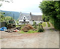
1
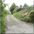
Track to Gellipistyll farm, Tranch
The track heads away from the junction of Tranch Road and Coch-y-north Road towards the Grade II listed Gellipistyll farmhouse. http://www.geograph.org.uk/photo/2415159
Image: © Jaggery
Taken: 16 May 2011
0.06 miles
2
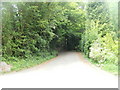
Coch-y-north Road, Tranch, Pontypool
The view from sunshine at the top (western) end of Tranch Road into the wooded gloom of Coch-y-north Road.
Image: © Jaggery
Taken: 16 May 2011
0.06 miles
3
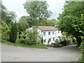
House at the top end of Tranch Road, Pontypool
Viewed from the junction of Tranch Road and Coch-y-north Road, near the track http://www.geograph.org.uk/photo/2415165 to Grade II listed Gellipistyll farmhouse. http://www.geograph.org.uk/photo/2415159
Image: © Jaggery
Taken: 16 May 2011
0.06 miles
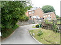
4
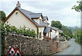
Modern houses, Tranch Road, Pontypool
Recently-built houses on the north side of Tranch Road, Tranch, opposite Hill Close.
Image: © Jaggery
Taken: 16 May 2011
0.09 miles
5
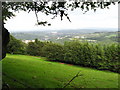
View over fields and woodland to Pontypool and beyond.
The view is of grazing land edged with beech woodland. Pontypool is visible in the distance, and beyond it you can just see Llandegfedd reservoir. This is very obvious when you are there but is very small in the photograph.
Image: © Jessica Aidley
Taken: 6 Jul 2007
0.13 miles
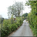
6
Twissell's Road, Tranch, Pontypool
Houses on the west side of the road viewed from Tranch Road.
Image: © Jaggery
Taken: 16 May 2011
0.14 miles
7
Narrow Tranch Road, Pontypool
The view west along narrow, pavementless Tranch Road, west of the Twissell's Road turning. http://www.geograph.org.uk/photo/2415117
Image: © Jaggery
Taken: 16 May 2011
0.14 miles
8
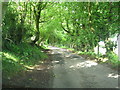
Coch-y-north Road
Overgrown beech hedging now forms a row of beautiful trees forming a tunnel over this road. The road is so narrow passing places (like the one on the left) have to be used when two vehicles meet.
Image: © Jessica Aidley
Taken: 6 Jul 2007
0.14 miles
9
Grade II listed Gellipistyll farmhouse, Tranch
A late 16th century building with a stone-tiled roof (the right side) with a 17th century slate-roofed addition on the left. Grade II listed in 2003.
Image: © Jaggery
Taken: 16 May 2011
0.14 miles