IMAGES TAKEN NEAR TO
Coed Y Gric Road, PONTYPOOL, NP4 5YA
Introduction
This page details the photographs taken nearby to Coed Y Gric Road, NP4 5YA by members of the Geograph project.
The Geograph project started in 2005 with the aim of publishing, organising and preserving representative images for every square kilometre of Great Britain, Ireland and the Isle of Man.

There are currently over 7.5m images from over14,400 individuals and you can help contribute to the project by visiting https://www.geograph.org.uk
Image Map
Images are licensed for reuse under creativecommons.org/licenses/by-sa/2.0
Notes
- Clicking on the map will re-center to the selected point.
- The higher the marker number, the further away the image location is from the centre of the postcode.
Image Listing (145 Images Found)
Images are licensed for reuse under creativecommons.org/licenses/by-sa/2.0
Image
Details
Distance
2
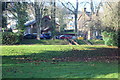
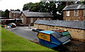
Cardiac Rehabilitation Unit, County Hospital, Griffithstown
The unit (old bell tower just visible) is in a former school on the edge of the hospital grounds.
Image: © M J Roscoe
Taken: 18 Dec 2017
0.05 miles
3
Sign on the Monmouthshire and Brecon Canal
Sign on the Monmouthshire and Brecon Canal near Pontypool.
Image: © Philip Halling
Taken: 12 Apr 2013
0.06 miles
4
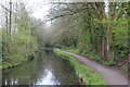
Monmouthshire & Brecon Canal, Griffithstown
Looking north, the canal runs alongside the County Hospital. The tow path is part of NCR 49.
Image: © M J Roscoe
Taken: 12 Apr 2019
0.06 miles
5
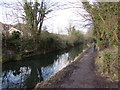
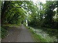
Walking the Mon & Brec path in Griffithstown, Pontypool
Looking north along the Monmouthshire & Brecon Canal.
Image: © Jaggery
Taken: 24 Jan 2015
0.06 miles
6
Western side of County Hospital, Griffithstown, Pontypool
Viewed from Coedygric Road.
Image: © Jaggery
Taken: 9 Aug 2014
0.06 miles
7
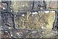
Ordnance Survey Cut Mark
This inverted OS cut mark can be found on the wall of the Hospital, Coedygric Road. It marks a point 124.733m above mean sea level.
Image: © Adrian Dust
Taken: 16 Feb 2021
0.06 miles
8
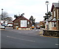
Entrance to County Hospital, Pontypool
Viewed across Coedygric Road from near the corner of Broad Street, Griffithstown.
Image: © Jaggery
Taken: 21 Jan 2011
0.07 miles
9
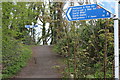
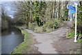
National Cycle Route signs, Griffithstown
NCRs 49 and 492 are close together here. The near bilingual sign is on the canal tow path, NCR 49, and appears to have been twisted round. The large sign should be pointing along the towpath, not to the far signpost. The far signpost is by NCR 492, on a dismantled railway.
Image: © M J Roscoe
Taken: 12 Apr 2019
0.07 miles
10
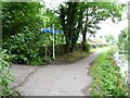
Cycleway signpost on the Mon & Brec canal towpath
The third arm points up to the cycle route on the former railway line.
Image: © Christine Johnstone
Taken: 15 Sep 2013
0.07 miles