IMAGES TAKEN NEAR TO
Clos Bach, PONTYPOOL, NP4 5SW
Introduction
This page details the photographs taken nearby to Clos Bach, NP4 5SW by members of the Geograph project.
The Geograph project started in 2005 with the aim of publishing, organising and preserving representative images for every square kilometre of Great Britain, Ireland and the Isle of Man.

There are currently over 7.5m images from over14,400 individuals and you can help contribute to the project by visiting https://www.geograph.org.uk
Image Map
Images are licensed for reuse under creativecommons.org/licenses/by-sa/2.0
Notes
- Clicking on the map will re-center to the selected point.
- The higher the marker number, the further away the image location is from the centre of the postcode.
Image Listing (72 Images Found)
Images are licensed for reuse under creativecommons.org/licenses/by-sa/2.0
Image
Details
Distance
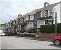
1
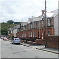
St Matthew's Road, Pontypool
Houses on the west side of the road.
Image: © Jaggery
Taken: 9 Jun 2011
0.03 miles
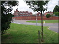
2
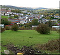
Cwm Fields area of Pontypool
Viewed from Prescoch Lane. The long line of houses in the middle of the view are on St Matthews Road, http://www.geograph.org.uk/photo/2451852 adjacent to the playing area of Pontymoile Primary School.
Image: © Jaggery
Taken: 26 Oct 2011
0.08 miles
3
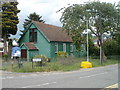
St Matthew's Church, Pontypool
There was a time, decades ago, when prefabricated corrugated-metal churches ("tin churches") were a common sight in many parts of the UK. Many have now been replaced by more modern buildings, but in Pontypool, two remain in use within about a kilometre of each other.
This one, on Victoria Road, is St Matthew's Church, Pontymoile, a Church in Wales church, diocese of Monmouth.
The other one is Race Methodist Church http://www.geograph.org.uk/photo/2452335 in Upper Race.
Image: © Jaggery
Taken: 9 Jun 2011
0.09 miles
4
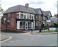
Former post office, Blaendare Road, Pontypool
A postbox is sometimes an indicator that the adjacent premises were formerly a post office. Such is the case here, on the corner of Blaendare Road and St Matthew's Road, Pontypool. Now The Batchelor Barber, this was Penygraig Terrace post office until closure in 2008.
Image: © Jaggery
Taken: 9 Jun 2011
0.09 miles
5
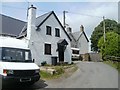
Cwm Farm, Pontypool
At the end of Cwm Farm Lane are Cwm Farm Cottage and, behind it, Cwm Farm House.
Behind the camera, the lane connects with Cwmynyscoy Road.
Image: © Jaggery
Taken: 13 Jun 2011
0.10 miles
6
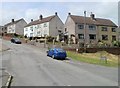
Hillside Drive houses, Pontypool
Houses in the Cwm Fields area of Pontypool, viewed from the corner of Cwm Farm Lane.
Image: © Jaggery
Taken: 13 Jun 2011
0.11 miles
7
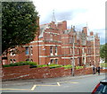
Southern side of West Monmouth School, Pontypool
Viewed across Blaendare Road. The school http://www.geograph.org.uk/photo/2451805 was Grade II listed in 1997.
Image: © Jaggery
Taken: 9 Jun 2011
0.11 miles
8
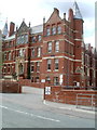
Entrance to West Monmouth School, Pontypool
The SE side of the Grade II listed school, http://www.geograph.org.uk/photo/2451805 viewed across Blaendare Road.
Image: © Jaggery
Taken: 9 Jun 2011
0.11 miles
9
West Monmouth School Pontypool
West Monmouth School Pontypool Opened in 1898 Jones West Monmouth Grammar School for Boys was built used funds provided by the Worshipful Company of Haberdashers “West Mon” is now a comprehensive school for both sexes
Image: © gj
Taken: 23 Jun 2006
0.11 miles
10
Farm Road houses, Pontypool
Viewed from the corner of Blaendare Road.
Image: © Jaggery
Taken: 9 Jun 2011
0.11 miles