IMAGES TAKEN NEAR TO
Mynydd View, PONTYPOOL, NP4 5SJ
Introduction
This page details the photographs taken nearby to Mynydd View, NP4 5SJ by members of the Geograph project.
The Geograph project started in 2005 with the aim of publishing, organising and preserving representative images for every square kilometre of Great Britain, Ireland and the Isle of Man.

There are currently over 7.5m images from over14,400 individuals and you can help contribute to the project by visiting https://www.geograph.org.uk
Image Map
Images are licensed for reuse under creativecommons.org/licenses/by-sa/2.0
Notes
- Clicking on the map will re-center to the selected point.
- The higher the marker number, the further away the image location is from the centre of the postcode.
Image Listing (38 Images Found)
Images are licensed for reuse under creativecommons.org/licenses/by-sa/2.0
Image
Details
Distance
1
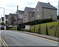
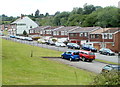
Blaendare Road houses, Pontypool
Houses on the north side of the road, about 80 metres SW of the junction with Hillside Drive.
Image: © Jaggery
Taken: 9 Jun 2011
0.07 miles
2
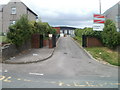
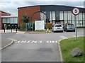
Entrance to Pontypool Campus, Coleg Gwent
The entrance to the campus is from Blaendare Road. This site is one of five Coleg Gwent campuses. The others are in Newport, Crosskeys, Ebbw Vale and Usk. Coleg Gwent is the largest further education college in Wales, with a typical enrolment of 35,000 students.
Image: © Jaggery
Taken: 9 Jun 2011
0.09 miles
3
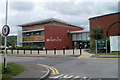
Campus building, Pontypool
Viewed from the entrance drive http://www.geograph.org.uk/photo/2451928 to the Coleg Gwent Pontypool Campus. At the right edge of the view is a colliery shaft winding wheel. http://www.geograph.org.uk/photo/2452299
Image: © Jaggery
Taken: 9 Jun 2011
0.11 miles
4
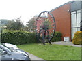
Winding wheel, Coleg Gwent Pontypool campus
A former colliery shaft winding wheel faces the entrance drive http://www.geograph.org.uk/photo/2451928 to the campus. A padlocked chain prevents the wheel being rotated.
Image: © Jaggery
Taken: 9 Jun 2011
0.11 miles
5
Wheel at entrance to Coleg Gwent Pontypool Campus
A former colliery shaft winding wheel faces the entrance drive http://www.geograph.org.uk/photo/2451928 from Blaendare Road.
http://www.geograph.org.uk/photo/2452299 to a closer view.
Image: © Jaggery
Taken: 9 Jun 2011
0.11 miles
6
Cwmynyscoy Road, Pontypool
Cwmynyscoy Road, from Penyrheol, descends towards central Pontypool
past the Wheatsheaf Inn http://www.geograph.org.uk/photo/2461888 and a row of houses.
Image: © Jaggery
Taken: 13 Jun 2011
0.12 miles
7
Side road,Cwmynyscoy, Pontypool
The unnamed side road is on the south side of Cwmynyscoy Road. The distant white building is the Wheatsheaf Inn. http://www.geograph.org.uk/photo/2461888
Image: © Jaggery
Taken: 13 Jun 2011
0.12 miles
8
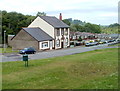
Green, houses and a pub, Cwmynyscoy, Pontypool
A view across an open space past houses on the north side of Cwmynyscoy Road.
The Wheatsheaf Inn http://www.geograph.org.uk/photo/2461888 is in the distance.
Image: © Jaggery
Taken: 13 Jun 2011
0.12 miles
9
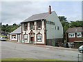
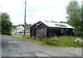
The Wheatsheaf Inn, Cwmynyscoy, Pontypool
Pub on the north side of Cwmynyscoy Road. With many pubs elsewhere closed down, it is surprising that there are two open pubs only about 140 metres apart in the small community of Cwmynyscoy.
The other one is The Unicorn Inn. http://www.geograph.org.uk/photo/2461941
Image: © Jaggery
Taken: 13 Jun 2011
0.12 miles
10
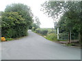
Northern boundary of Penyrheol, Torfaen
Just beyond a 90 degree bend in the road, Cwmynyscoy Road behind the camera becomes Penyrheol Road ahead. The Penyrheol boundary sign is on the right, partly obscured by vegetation.
There are several communities named Penyrheol or Pen-yr-heol in Wales. This one is in SE Wales, in Torfaen, between Pontypool and Cwmbran.
Image: © Jaggery
Taken: 13 Jun 2011
0.12 miles