IMAGES TAKEN NEAR TO
Panteg Industrial Estate, Station Road, PONTYPOOL, NP4 5LX
Introduction
This page details the photographs taken nearby to Panteg Industrial Estate, Station Road, NP4 5LX by members of the Geograph project.
The Geograph project started in 2005 with the aim of publishing, organising and preserving representative images for every square kilometre of Great Britain, Ireland and the Isle of Man.

There are currently over 7.5m images from over14,400 individuals and you can help contribute to the project by visiting https://www.geograph.org.uk
Image Map
Images are licensed for reuse under creativecommons.org/licenses/by-sa/2.0
Notes
- Clicking on the map will re-center to the selected point.
- The higher the marker number, the further away the image location is from the centre of the postcode.
Image Listing (154 Images Found)
Images are licensed for reuse under creativecommons.org/licenses/by-sa/2.0
Image
Details
Distance
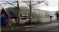
1

Changing Gearz in Pontypool
Based here in Panteg Industrial Estate, the Changing Gearz Project is part of the LIFT/CODI Youth Project within Blaenau Gwent, Caerphilly and Torfaen. Changing Gearz aims to train young people in bicycle maintenance & repair. To be involved, a person must less than 25 years old and meet the neets' criteria.
A neet is a young person who is no longer in the education system, not working nor being trained for work.
Image: © Jaggery
Taken: 24 Jan 2015
0.01 miles
2
Yearnhome Joinery, Pontypool
Hardwood & softwood purpose-made joinery business in Panteg Industrial Estate.
Image: © Jaggery
Taken: 24 Jan 2015
0.02 miles
3
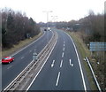
A4042 heading south, Pontypool
Viewed from a New Road bridge. The A4042 heads towards Cwmbran.
Image: © Jaggery
Taken: 21 Jan 2011
0.03 miles
4
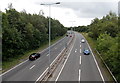
A4042 south of New Road, Pontypool
This is a former railway route in a formerly very busy railway area near Pontypool Road railway station and locomotive shed. The locomotive shed and most of the lines have gone. The railway station, now named Pontypool & New Inn, is much reduced from its former glory.
Image: © Jaggery
Taken: 9 Aug 2014
0.04 miles
5
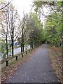
Former railway line near Griffithstown
Image: © Gareth James
Taken: 23 Oct 2011
0.04 miles
6
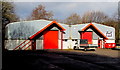
Units at the northern end of Panteg Industrial Estate, Pontypool
The name of the right is SOUTH WALES PRESS TOOLS.
Image: © Jaggery
Taken: 24 Jan 2015
0.05 miles
7
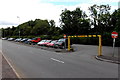
Exit from a free car park in Griffithstown, Pontypool
The exit from the long narrow Station Road car park is about 100 metres from the entrance.
The metal frame (and a similar one at the entrance) enforces a vehicle height limit of 2.1 metres (6' 10").
Long and narrow car parks are often on former railway land. Such is the case here. Old maps show a railway here, north of Panteg and Griffithstown railway station http://www.geograph.org.uk/photo/4115072 where passenger services ceased at the end of April 1962.
Image: © Jaggery
Taken: 9 Aug 2014
0.07 miles
8
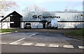
SC Sporthomes in Pontypool
Manufacturers of luxury motorhomes for sport and leisure, located in Panteg Industrial Estate.
Image: © Jaggery
Taken: 24 Jan 2015
0.08 miles
9
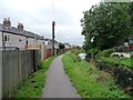
Mon & Brec canal, Griffithstown
Looking south between Commercial Street and Station Road.
Image: © Christine Johnstone
Taken: 15 Sep 2013
0.08 miles
10
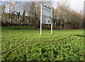
Panteg Industrial Estate nameboard, Pontypool
Panteg Industrial Estate is located between Station Road to the west and the A4042 to the east.
Image: © Jaggery
Taken: 24 Jan 2015
0.08 miles