IMAGES TAKEN NEAR TO
Hillside Road, PONTYPOOL, NP4 5LP
Introduction
This page details the photographs taken nearby to Hillside Road, NP4 5LP by members of the Geograph project.
The Geograph project started in 2005 with the aim of publishing, organising and preserving representative images for every square kilometre of Great Britain, Ireland and the Isle of Man.

There are currently over 7.5m images from over14,400 individuals and you can help contribute to the project by visiting https://www.geograph.org.uk
Image Map
Images are licensed for reuse under creativecommons.org/licenses/by-sa/2.0
Notes
- Clicking on the map will re-center to the selected point.
- The higher the marker number, the further away the image location is from the centre of the postcode.
Image Listing (75 Images Found)
Images are licensed for reuse under creativecommons.org/licenses/by-sa/2.0
Image
Details
Distance
1
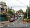
Hillside Road, Griffithstown, Pontypool
Viewed from roughly the point where Sunnybank Road becomes Stafford Road.
Image: © Jaggery
Taken: 21 Oct 2009
0.02 miles
2
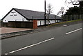
Kingdom Hall below Stafford Road, Griffithstown, Pontypool
Viewed in late January 2015. The hall is recently built. A Google Earth Street View taken in June 2011 shows a vacant plot here. Jehovah's Witnesses use Kingdom Hall to describe their places of worship because the biblical use of church usually refers to the congregation of people rather than a structure.
Image: © Jaggery
Taken: 27 Jan 2015
0.04 miles
3
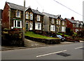
Sunnybank Road houses in Griffithstown, Pontypool
On the west side of the road, between Mountain Lane and Hillside Road.
Image: © Jaggery
Taken: 27 Jan 2015
0.05 miles
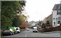
4
Unclassified Stafford Road, Griffithstown, Pontypool
I assumed that this busy road and a major bus route would be a B road if not an A road. I was surprised to find that Stafford Road is unclassified. There are very few classified roads in this area.
Image: © Jaggery
Taken: 27 Jan 2015
0.06 miles
5
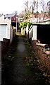
Short cut from Coedygric Road to Stafford Road, Griffithstown, Pontypool
A 90 metre long footpath connects the two streets.
Image: © Jaggery
Taken: 24 Jan 2015
0.07 miles
6
Coed-y-Gric Road, Griffithstown, Pontypool
Viewed from Stafford Road. The trees on the left are on the southern edge of County Hospital.
Image: © Jaggery
Taken: 21 Oct 2009
0.07 miles
7
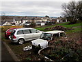
Two cars and two ex-cars in Griffithstown, Pontypool
Viewed in midwinter. No doubt the brambles will cover the remains of the car on the right next summer.
Image: © Jaggery
Taken: 27 Jan 2015
0.08 miles
8
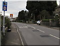
Speed camera sign, Stafford Road, Griffithstown, Pontypool
Behind the speed camera sign, a Playground sign is on the approach to a large recreation area.
Image: © Jaggery
Taken: 27 Jan 2015
0.08 miles
9
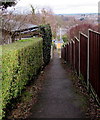
Between hedge and fence, Griffithstown, Pontypool
A footpath descends from Stafford Road to Coedygric Road.
Image: © Jaggery
Taken: 27 Jan 2015
0.08 miles
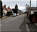
10
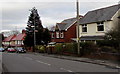
Housing variety in Griffithstown, Pontypool
Houses on the east side of Stafford Road.
Image: © Jaggery
Taken: 27 Jan 2015
0.09 miles