IMAGES TAKEN NEAR TO
Stafford Road, PONTYPOOL, NP4 5LJ
Introduction
This page details the photographs taken nearby to Stafford Road, NP4 5LJ by members of the Geograph project.
The Geograph project started in 2005 with the aim of publishing, organising and preserving representative images for every square kilometre of Great Britain, Ireland and the Isle of Man.

There are currently over 7.5m images from over14,400 individuals and you can help contribute to the project by visiting https://www.geograph.org.uk
Image Map
Images are licensed for reuse under creativecommons.org/licenses/by-sa/2.0
Notes
- Clicking on the map will re-center to the selected point.
- The higher the marker number, the further away the image location is from the centre of the postcode.
Image Listing (89 Images Found)
Images are licensed for reuse under creativecommons.org/licenses/by-sa/2.0
Image
Details
Distance
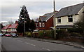
1
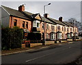
Row of houses, Stafford Road, Griffithstown, Pontypool
Illuminated by late January sunshine.
Image: © Jaggery
Taken: 27 Jan 2015
0.02 miles
2
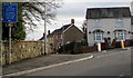
Outdated sign, Griffithstown, Pontypool
Viewed across Stafford Road in January 2015. Depicting a toy railway locomotive, a small brown sign points left towards Coedygric Road, formerly a route to Griffithstown Railway Museum, which closed down in 2011.
When I visited the site in August 2014, the former museum was occupied by Little Chums Nursery. http://www.geograph.org.uk/photo/4113940
Image: © Jaggery
Taken: 27 Jan 2015
0.03 miles
3
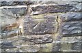
Ordnance Survey Cut Mark
This OS cut mark can be found on the wall of No127 Sunnybank Road. It marks a point 134.947m above mean sea level.
Image: © Adrian Dust
Taken: 16 Feb 2021
0.03 miles
4
Coedygric Road, Griffithstown, Pontypool
Coedygric Road climbs towards Stafford Road.
Image: © Jaggery
Taken: 24 Jan 2015
0.03 miles
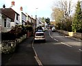
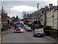
5
Stafford Road, Griffithstown, Pontypool
Houses on the eastern side of Stafford Road. A fire engine on an emergency callout races by on the left.
Image: © Jaggery
Taken: 21 Oct 2009
0.04 miles
6
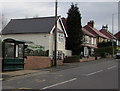
Not much of a bus shelter, Stafford Road, Griffithstown, Pontypool
This shelter with a small roof and no sides would be all right if the rain (or snow) always fell vertically and was never blown horizontally by the wind. On the plus side, a long timetable in the shelter shows a frequent bus service (except on Sundays) so passengers shouldn't have long to wait here.
Image: © Jaggery
Taken: 27 Jan 2015
0.05 miles
7
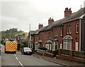
Emergency fire engine, Stafford Road, Griffithstown, Pontypool
Sirens sounding and blue lights flashing, a fire engine speeds north along Stafford Road.
Image: © Jaggery
Taken: 27 Jan 2015
0.05 miles
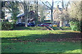
8
Western side of County Hospital, Griffithstown, Pontypool
Viewed from Coedygric Road.
Image: © Jaggery
Taken: 9 Aug 2014
0.06 miles
9
Housing variety in Griffithstown, Pontypool
Houses on the east side of Stafford Road.
Image: © Jaggery
Taken: 27 Jan 2015
0.07 miles
10
Cardiac Rehabilitation Unit, County Hospital, Griffithstown
The unit (old bell tower just visible) is in a former school on the edge of the hospital grounds.
Image: © M J Roscoe
Taken: 18 Dec 2017
0.08 miles