IMAGES TAKEN NEAR TO
Austin Road, PONTYPOOL, NP4 5ER
Introduction
This page details the photographs taken nearby to Austin Road, NP4 5ER by members of the Geograph project.
The Geograph project started in 2005 with the aim of publishing, organising and preserving representative images for every square kilometre of Great Britain, Ireland and the Isle of Man.

There are currently over 7.5m images from over14,400 individuals and you can help contribute to the project by visiting https://www.geograph.org.uk
Image Map
Images are licensed for reuse under creativecommons.org/licenses/by-sa/2.0
Notes
- Clicking on the map will re-center to the selected point.
- The higher the marker number, the further away the image location is from the centre of the postcode.
Image Listing (141 Images Found)
Images are licensed for reuse under creativecommons.org/licenses/by-sa/2.0
Image
Details
Distance
1
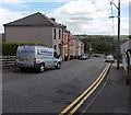
Down Austin Road, Sebastopol, Pontypool
Austin Road descends from Wern Road towards Station Road.
Image: © Jaggery
Taken: 9 Aug 2014
0.00 miles
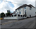
2
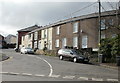
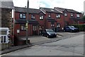
Austin Road, Sebastopol
Houses on the north side of Austin Road, viewed from the corner of Station Road.
Image: © Jaggery
Taken: 21 Oct 2009
0.01 miles
3
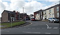
Up Austin Road, Sebastopol, Pontypool
Austin Road ascends towards Wern Road from Station Road.
Image: © Jaggery
Taken: 9 Aug 2014
0.01 miles
4
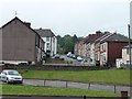
Houses on Austin Road
Looking west from the former railway line.
Image: © Christine Johnstone
Taken: 15 Sep 2013
0.01 miles
5
Row of three houses in Austin Road, Sebastopol, Pontypool
These brick houses look several decades newer than the stone house on the left.
Image: © Jaggery
Taken: 9 Aug 2014
0.03 miles
6
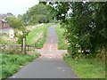
Dropped bridge on former railway line, Sebastopol
No need to maintain a bridge when the route is now a cycleway and footpath.
Image: © Christine Johnstone
Taken: 15 Sep 2013
0.04 miles
7
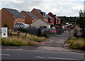
All site traffic and deliveries this way, Station Road, Pontypool
Opposite the Austin Road junction, http://www.geograph.org.uk/photo/4113300 a sign points towards locked grey gates.
A notice inside the site shows PRIVATE LAND - NETWORK RAIL. The nearly 200 metre long site is between houses in St Dunstan's Close to the north (on the left here) and Parc Panteg to the south.
Image: © Jaggery
Taken: 9 Aug 2014
0.04 miles
8

Footpath and cycleway south of Churchwood, Pontypool
On the route of a former railway line at the edge of steelworks, both now gone.
Image: © Jaggery
Taken: 9 Aug 2014
0.04 miles
9
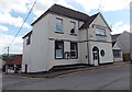
Sebastopol Social Club, Pontypool
Occupying the corner of Wern Road and Austin Road. The club's website states that after Major A.I.R. Butler donated a small piece of land in Wern Road in 1922, a temporary building was erected for use by ex-servicemen. On Saturday March 19th 1927, the Panteg branch of the British Legion made its home in the permanent building seen here. The club has survived many transitions and is still used by former Royal Regiment of Wales servicemen for their meetings.
Image: © Jaggery
Taken: 9 Aug 2014
0.04 miles
10
Austin Road side of Sebastopol Social Club, Pontypool
See http://www.geograph.org.uk/photo/4113207 for another view and some details.
Image: © Jaggery
Taken: 9 Aug 2014
0.04 miles