IMAGES TAKEN NEAR TO
Railway Terrace, PONTYPOOL, NP4 5EJ
Introduction
This page details the photographs taken nearby to Railway Terrace, NP4 5EJ by members of the Geograph project.
The Geograph project started in 2005 with the aim of publishing, organising and preserving representative images for every square kilometre of Great Britain, Ireland and the Isle of Man.

There are currently over 7.5m images from over14,400 individuals and you can help contribute to the project by visiting https://www.geograph.org.uk
Image Map
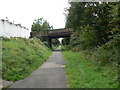
Images are licensed for reuse under creativecommons.org/licenses/by-sa/2.0
Notes
- Clicking on the map will re-center to the selected point.
- The higher the marker number, the further away the image location is from the centre of the postcode.
Image Listing (128 Images Found)
Images are licensed for reuse under creativecommons.org/licenses/by-sa/2.0
Image
Details
Distance
1
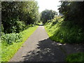
Footpath along route of former railway line near Sebastopol
Viewed from the site of the demolished Sebastopol railway station, which closed in 1962.
The footpath and cycle route use the route of the dismantled railway.
The path branching off in the lower right corner leads up to Avondale Road
near the southern boundary of Sebastopol.
Image: © Jaggery
Taken: 18 Aug 2012
0.02 miles
2
Path south from Avondale Road, Sebastopol, Pontypool
The path uses the route of a dismantled railway near the demolished Sebastopol railway station.
Viewed from this http://www.geograph.org.uk/photo/4321748 road bridge.
Image: © Jaggery
Taken: 24 Jan 2015
0.03 miles
3
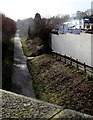
Looking north along Railway Terrace, Sebastopol
Viewed from the edge of a stile. http://www.geograph.org.uk/photo/3087721
Image: © Jaggery
Taken: 18 Aug 2012
0.03 miles
4
Southern end of Railway Terrace, Sebastopol
About 150 metres south of its northern end, Railway Terrace ends at a stile. http://www.geograph.org.uk/photo/3087721
Image: © Jaggery
Taken: 18 Aug 2012
0.04 miles
5
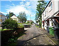
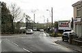
Southwest edge of Sebastopol,Pontypool
The junction of South Street (to the left) and Station Road (to the right).
Sebastopol is the southernmost suburb of Pontypool. It was named to commemorate the capture of the Crimean city, now called Sevastopol, at the end of the 1854-1855 Siege of Sevastopol during the Crimean War.
Image: © Jaggery
Taken: 21 Oct 2009
0.04 miles
6
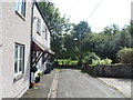
Avondale Road, Pontypool
Looking towards Avondale Road from South Street, Sebastopol. In the distance are the chimneys of Knauf Insulation http://www.geograph.org.uk/photo/1577012
Image: © Jaggery
Taken: 21 Oct 2009
0.04 miles
7
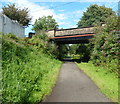
Road bridge over footpath near Sebastopol
Avondale Road crosses over a footpath and cycleway, formerly a railway line.
This was the location of Sebastopol railway station which closed in 1962.
Image: © Jaggery
Taken: 18 Aug 2012
0.04 miles
8
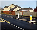
Pedestrian refuge in Avondale Road, Pontypool
Viewed at a rare traffic-free moment on a busy road between Cwmbran and Pontypool. The refuge enables a walker to cross the road in two goes if necessary, without needing to wait for a gap in traffic from both directions.
The small single-storey building behind the railings is an electricity substation. http://www.geograph.org.uk/photo/4321675
Image: © Jaggery
Taken: 24 Jan 2015
0.05 miles
10
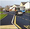
X24 bus, Avondale Road, Pontypool
The Stagecoach bus is on route X24 from Blaenavon to Newport via Pontypool and Cwmbran.
Image: © Jaggery
Taken: 24 Jan 2015
0.05 miles