IMAGES TAKEN NEAR TO
Maes Y Celyn, PONTYPOOL, NP4 5DG
Introduction
This page details the photographs taken nearby to Maes Y Celyn, NP4 5DG by members of the Geograph project.
The Geograph project started in 2005 with the aim of publishing, organising and preserving representative images for every square kilometre of Great Britain, Ireland and the Isle of Man.

There are currently over 7.5m images from over14,400 individuals and you can help contribute to the project by visiting https://www.geograph.org.uk
Image Map
Images are licensed for reuse under creativecommons.org/licenses/by-sa/2.0
Notes
- Clicking on the map will re-center to the selected point.
- The higher the marker number, the further away the image location is from the centre of the postcode.
Image Listing (89 Images Found)
Images are licensed for reuse under creativecommons.org/licenses/by-sa/2.0
Image
Details
Distance
1
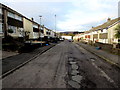
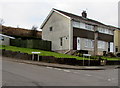
Patchy road surface, Maes-y-Celyn, Pontypool
Viewed from the Bryn Heulog end looking north. The distant white building is Maesderwen Rise. http://www.geograph.org.uk/photo/4325556
Image: © Jaggery
Taken: 27 Jan 2015
0.03 miles
2
Long bus stop on the east side of Stafford Road, Pontypool
The area marked as a bus stop extends for 65 metres.
Image: © Jaggery
Taken: 27 Jan 2015
0.05 miles
3
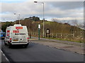
Iceland home delivery van, Stafford Road, Pontypool
Viewed in late January 2015 when Iceland shoppers (in-store or via the Iceland website)
can have free home delivery if they spend at least £25.
Image: © Jaggery
Taken: 27 Jan 2015
0.05 miles
4
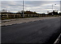
Give way to oncoming vehicles, Stafford Road, Griffithstown, Pontypool
A northbound vehicle should stop at the broken white lines if a
southbound vehicle is approaching the short single-lane section of road ahead.
Image: © Jaggery
Taken: 27 Jan 2015
0.05 miles
5
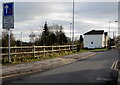
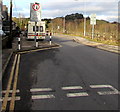
Priority over oncoming vehicles sign, Stafford Road, Pontypool
Part of a traffic calming area.
Image: © Jaggery
Taken: 27 Jan 2015
0.05 miles
6
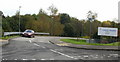
Entrance road to County Hospital, Griffithstown
From Stafford Road.
Image: © Jaggery
Taken: 21 Oct 2009
0.05 miles
7
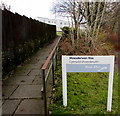
Path from Stafford Road to Maesderwen Rise, Pontypool
Maesderwen Rise http://www.geograph.org.uk/photo/4325556 is managed by Bron Afon Community Housing Association.
Image: © Jaggery
Taken: 27 Jan 2015
0.06 miles
8
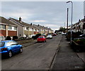
South along Maes-y-Celyn, Pontypool
Viewed from the northern end of Maes-y-Celyn looking towards the Bryn Heulog
junction about 150 metres ahead. Maesderwen Rise http://www.geograph.org.uk/photo/4325556 is behind the camera.
Image: © Jaggery
Taken: 27 Jan 2015
0.06 miles
9
Junction of Bryn Heulog and Maes-y-Celyn, Pontypool
Bryn Heulog on the left, Maes-y-Celyn on the right.
Image: © Jaggery
Taken: 27 Jan 2015
0.06 miles
10
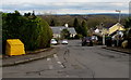
Yellow grit box and a yellowish grit box, Bryn Heulog, Pontypool
The vivid yellow of the box on the left contrasts with the dingy/dirty yellow of the one on the right.
Image: © Jaggery
Taken: 27 Jan 2015
0.06 miles