IMAGES TAKEN NEAR TO
Commercial Street, PONTYPOOL, NP4 5DF
Introduction
This page details the photographs taken nearby to Commercial Street, NP4 5DF by members of the Geograph project.
The Geograph project started in 2005 with the aim of publishing, organising and preserving representative images for every square kilometre of Great Britain, Ireland and the Isle of Man.

There are currently over 7.5m images from over14,400 individuals and you can help contribute to the project by visiting https://www.geograph.org.uk
Image Map
Images are licensed for reuse under creativecommons.org/licenses/by-sa/2.0
Notes
- Clicking on the map will re-center to the selected point.
- The higher the marker number, the further away the image location is from the centre of the postcode.
Image Listing (147 Images Found)
Images are licensed for reuse under creativecommons.org/licenses/by-sa/2.0
Image
Details
Distance
1
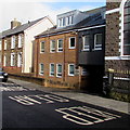
Keep clear on Commercial Street, Griffithstown, Pontypool
Outside Mcintyre Court flats.
Image: © Jaggery
Taken: 24 Jan 2015
0.01 miles
2
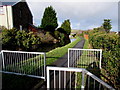
Canal path barriers, Griffithstown, Pontypool
Preventing vehicular misuse of the footpath & cycleway on the former towpath of the Monmouthshire & Brecon Canal north of Kemys Street and canal bridge 49. http://www.geograph.org.uk/photo/4330861 This is part of National Cycle Network Route 49.
Image: © Jaggery
Taken: 24 Jan 2015
0.02 miles
3
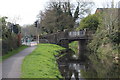
Bridge 49, Monmouthshire & Brecon Canal
Northern side of bridge carrying Kemys Street over canal
Image: © M J Roscoe
Taken: 12 Apr 2019
0.02 miles
4
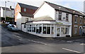
Hairs & Graces, Griffithstown, Pontypool
Hair salon at 1 Commercial Street, on the corner of Kemys Street.
Image: © Jaggery
Taken: 24 Jan 2015
0.03 miles
5
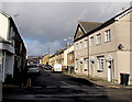
North along Commercial Street, Griffithstown, Pontypool
From Kemys Street.
Image: © Jaggery
Taken: 24 Jan 2015
0.03 miles
6
![Panteg Bridge [no 49] from the north](https://s3.geograph.org.uk/geophotos/03/66/80/3668003_a94e5526_120x120.jpg)
Panteg Bridge [no 49] from the north
Carrying Kemys Street over the Mon & Brec canal. The towpath under the bridge was lost when it was rebuilt, so now walkers and cyclists are given their own set of traffic lights.
Image: © Christine Johnstone
Taken: 15 Sep 2013
0.03 miles
7
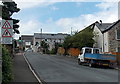
Kemys Street, Griffithstown, Pontypool
Looking west along Kemys Street from the corner of Station Road. Signs show that the road narrows ahead (across a bridge over the Monmouthshire & Brecon Canal), with no footway for 20 yards.
Traffic lights control an alternating flow of one-way traffic over the bridge.
Image: © Jaggery
Taken: 9 Aug 2014
0.03 miles
8
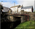
South side of Canal Bridge 49 in Griffithstown, Pontypool
The bridge carries Kemys Street over the disused Monmouthshire & Brecon Canal.
Image: © Jaggery
Taken: 24 Jan 2015
0.03 miles
9
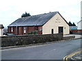
Kingdom Hall, Griffithstown, Pontypool
Located on Commercial Street.
A Kingdom Hall is a place of worship used by Jehovah's Witnesses. They use the term rather than 'church' because the biblical use of 'church' usually refers to the congregation of people rather than a structure.
Image: © Jaggery
Taken: 21 Jan 2011
0.03 miles
10
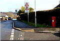
Shrunken postbox on a corner in Griffithstown, Pontypool
Only a couple of centimetres of the postbox's black base is above the surface on the corner of Canal Close and Kemys Street. A sign showing no footway for 20 yards is contradicted by the continuous pavement ahead.
Image: © Jaggery
Taken: 24 Jan 2015
0.03 miles