IMAGES TAKEN NEAR TO
Caerleon Road, CWMBRAN, NP44 8TU
Introduction
This page details the photographs taken nearby to Caerleon Road, NP44 8TU by members of the Geograph project.
The Geograph project started in 2005 with the aim of publishing, organising and preserving representative images for every square kilometre of Great Britain, Ireland and the Isle of Man.

There are currently over 7.5m images from over14,400 individuals and you can help contribute to the project by visiting https://www.geograph.org.uk
Image Map
Images are licensed for reuse under creativecommons.org/licenses/by-sa/2.0
Notes
- Clicking on the map will re-center to the selected point.
- The higher the marker number, the further away the image location is from the centre of the postcode.
Image Listing (98 Images Found)
Images are licensed for reuse under creativecommons.org/licenses/by-sa/2.0
Image
Details
Distance
1
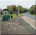
Bus stop, B4236, Llanfrechfa
The bus stop is used by the Newport Bus Monday-Saturday hourly service (route 29) from Newport to Cwmbran via Ponthir.
Ahead, just out of view, is the A4042 (Cwmbran Drive) roundabout ; on the left is the turning for Twm Barlwm View http://www.geograph.org.uk/photo/1633400 and Selby Close. http://www.geograph.org.uk/photo/1633413
Image: © Jaggery
Taken: 15 Oct 2009
0.06 miles
2
View from the bus stop opposite the hospital, near Llanfrechfa
Image: © Ruth Sharville
Taken: 28 Jan 2011
0.06 miles
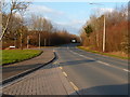
3
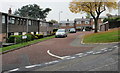
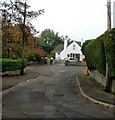
Crown Rise houses, Cwmbran
Viewed across the B4236 Caerleon Road. Beyond the left edge of the photo,
the B4236 leads to Llanfrechfa, Ponthir (both in Torfaen) and Caerleon
(in the city of Newport).
Image: © Jaggery
Taken: 26 Dec 2023
0.06 miles
4
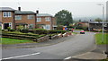
Buildings alongside Old Hospital Drive, Cwmbran
In the grounds of Grange University Hospital on the approach to the B4236 Caerleon Road junction.
Image: © Jaggery
Taken: 26 Dec 2023
0.07 miles
5
West Bank, Llanfrechfa
Viewed from Crown Rise.
Image: © Jaggery
Taken: 15 Oct 2009
0.08 miles
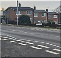
6
Crown Rise, Llanfrechfa
Houses on the south side of Crown Rise, between Caerleon Road (B4236) and the turning for West Bank, visible at the middle right edge of the photo.
Image: © Jaggery
Taken: 15 Oct 2009
0.08 miles
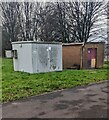
7
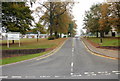
Entrance to Llanfrechfa Grange Hospital
Viewed from the B4236.
The local newspaper reported in December 2008 that the last residents had moved out of Llanfrechfa Grange Hospital for people with learning disabilities, ending more than 50 years of long-stay care at the site near Cwmbran.
The Grange site still houses an assessment and treatment centre for learning disability and healthcare needs, and remains in use as an administrative headquarters for Gwent Healthcare Trust. It is also likely that part of the site will be used for housing development, though until the Welsh Assembly formally approves the trust's proposal, its future remains unclear.
Image: © Jaggery
Taken: 15 Oct 2009
0.08 miles
8
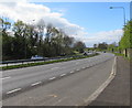
Turnpike Road, Llanyravon, Cwmbran
The A4042 Turnpike Road viewed from this http://www.geograph.org.uk/photo/5348464 bus stop.
The name is doubly historical - no tolls have been payable on Turnpike Road for many decades,
and what is now a dual carriageway road would have looked very different in the era when tolls were levied.
Image: © Jaggery
Taken: 12 Apr 2017
0.09 miles
9
Selby Close, Llanfrechfa
A short cul-de-sac adjacent to Twm Barlwm View and the B4236.
Image: © Jaggery
Taken: 15 Oct 2009
0.10 miles
10
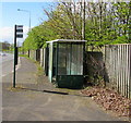
Turnpike Road bus stop and shelter, Llanyravon, Cwmbran
On the west side of the A4042 Turnpike Road, near a path to Liswerry Drive.
Route number 30 is shown on the bus stop pole, but that does not guarantee
that buses still use this route in April 2017. No timetables are on display here.
Image: © Jaggery
Taken: 12 Apr 2017
0.11 miles