IMAGES TAKEN NEAR TO
The Pastures, CWMBRAN, NP44 8SR
Introduction
This page details the photographs taken nearby to The Pastures, NP44 8SR by members of the Geograph project.
The Geograph project started in 2005 with the aim of publishing, organising and preserving representative images for every square kilometre of Great Britain, Ireland and the Isle of Man.

There are currently over 7.5m images from over14,400 individuals and you can help contribute to the project by visiting https://www.geograph.org.uk
Image Map
Images are licensed for reuse under creativecommons.org/licenses/by-sa/2.0
Notes
- Clicking on the map will re-center to the selected point.
- The higher the marker number, the further away the image location is from the centre of the postcode.
Image Listing (107 Images Found)
Images are licensed for reuse under creativecommons.org/licenses/by-sa/2.0
Image
Details
Distance
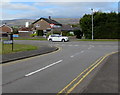
1
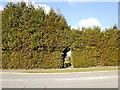
Hole in the hedge entrance to The Pastures, Llanyrafon
Pedestrians have a short cut into The Pastures through this hole in the hedge on the north side of Llanyrafon Way. On the other side of the hedge, steps lead down into The Pastures.
Image: © Jaggery
Taken: 11 Feb 2010
0.02 miles
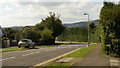
2
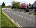
Up Llanyravon Way, Cwmbran
Llanyravon Way ascends towards the Croesyceiliog area of Cwmbran.
Llanyrafon Methodist Church http://www.geograph.org.uk/photo/5349208 is on the right.
In 2017, the Welsh Llanyrafon and the slightly Anglicised Llanyravon are
about equally common in English language use in this area of Cwmbran.
Image: © Jaggery
Taken: 12 Apr 2017
0.03 miles
3
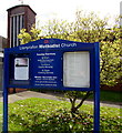
Llanyrafon Methodist Church information board, Cwmbran
Located here. http://www.geograph.org.uk/photo/5349208
Image: © Jaggery
Taken: 12 Apr 2017
0.03 miles
4
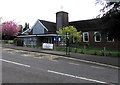
Llanyrafon Methodist Church, Cwmbran
This is the Llanyravon Way side of the church on the corner of Liswerry Drive.
The church is in the Gwent Hills & Vales Circuit of the Wales Synod, Methodist Church of Great Britain.
Llanyrafon in Welsh is also spelt Llanyravon in English. The two spellings appear
to be about equally common hereabouts in 2017. The church name uses Llanyrafon
whereas a nearby street name sign shows Llanyravon Way.
Image: © Jaggery
Taken: 12 Apr 2017
0.04 miles
5
Junction of Liswerry Drive and Llanyravon Way, Llanyravon, Cwmbran
Viewed across the northwest end of Liswerry Drive.
Image: © Jaggery
Taken: 12 Apr 2017
0.04 miles
6
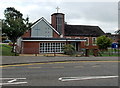
Llanyrafon Methodist Church, Cwmbran
Viewed across Llanyravon (or Llanyrafon) Way. The name above the church entrance uses the Welsh spelling Llanyrafon as does a nearby street name sign. Two other signs lower down the road show the slightly Anglicised spelling Llanyravon.
Image: © Jaggery
Taken: 30 Aug 2013
0.04 miles
7
Southeast side of Llanyrafon Methodist Church, Cwmbran
This is the Liswerry Drive side of the church on the corner of Llanyravon Way.
http://www.geograph.org.uk/photo/5349208 to the front of the church which is in the Gwent Hills & Vales Circuit
of the Wales Synod, Methodist Church of Great Britain.
Llanyrafon in Welsh is also spelt Llanyravon in English. The two spellings appear
to be about equally common hereabouts in 2017. The church name uses Llanyrafon
whereas a nearby street name sign shows Llanyravon Way.
Image: © Jaggery
Taken: 12 Apr 2017
0.04 miles
8
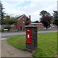
Postbox in a brick pillar, Cwmbran
Located on the corner of Llanyravon Way and Liswerry Drive.
Llanyrafon Methodist Church http://www.geograph.org.uk/photo/3632796 is in the background.
Image: © Jaggery
Taken: 30 Aug 2013
0.04 miles
9
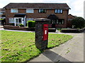
Queen Elizabeth II postbox in a brick pillar on a Cwmbran corner
On the corner of Llanyravon Way and Liswerry Drive in the Llanyravon area of Cwmbran.
Image: © Jaggery
Taken: 12 Apr 2017
0.04 miles
10
Llanyrafon Way, Croesyceiliog
Looking along Llanyrafon Way from the junction with Turnpike Road.
Image: © Jaggery
Taken: 8 Oct 2009
0.05 miles