IMAGES TAKEN NEAR TO
The Alders, CWMBRAN, NP44 8JE
Introduction
This page details the photographs taken nearby to The Alders, NP44 8JE by members of the Geograph project.
The Geograph project started in 2005 with the aim of publishing, organising and preserving representative images for every square kilometre of Great Britain, Ireland and the Isle of Man.

There are currently over 7.5m images from over14,400 individuals and you can help contribute to the project by visiting https://www.geograph.org.uk
Image Map
Images are licensed for reuse under creativecommons.org/licenses/by-sa/2.0
Notes
- Clicking on the map will re-center to the selected point.
- The higher the marker number, the further away the image location is from the centre of the postcode.
Image Listing (144 Images Found)
Images are licensed for reuse under creativecommons.org/licenses/by-sa/2.0
Image
Details
Distance
1
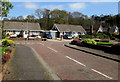
T junction in The Alders, Llanyravon, Cwmbran
The Alders is an area of modern houses located between Llanfrechfa Way and
the A4042 Turnpike Road in the Llanyravon district in the southeast of Cwmbran.
Image: © Jaggery
Taken: 7 Apr 2017
0.02 miles
2

Friars Garden bungalows, Llanyravon, Cwmbran
The south side of Friars Garden, a cul-de-sac between Bath Wood and the street named The Alders (ahead).
Image: © Jaggery
Taken: 7 Apr 2017
0.04 miles
3
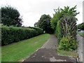
Path towards The Alders, Cwmbran
From Llanfrechfa Way in Llanyravon in the SE of Cwmbran.
Image: © Jaggery
Taken: 5 Aug 2019
0.05 miles
4

Friars Garden, Llanyravon, Cwmbran
Along the cul-de-sac Friars Garden from the edge of Bath Wood
looking towards the street named The Alders 75 metres ahead.
Image: © Jaggery
Taken: 7 Apr 2017
0.05 miles
5
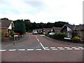
Friars Garden, Llanyravon, Cwmbran
Friars Garden is a residential cul-de-sac, viewed from The Alders looking towards Bath Wood.
Image: © Jaggery
Taken: 30 Aug 2013
0.05 miles
6

Friars Garden, Llanyravon, Cwmbran
The cul-de-sac Friars Garden extends for 75 metres from The Alders to the edge of Bath Wood.
The name sign on the right shows that Friars Garden is Gerddi'r Brodyr in Welsh.
Image: © Jaggery
Taken: 7 Apr 2017
0.05 miles
7
Wheelie bins at the edge of Bath Wood, Cwmbran
Bath Wood in the southeast of Cwmbran extends from the NE end of the cul-de-sac
Friars Garden (on this side) to the west side of the A4042 Turnpike Road.
Image: © Jaggery
Taken: 7 Apr 2017
0.05 miles
8

No longer a kissing gate at an entrance to Bath Wood, Cwmbran
Beyond the northeast end of the cul-de-sac Friars Garden, a track leads to Bath Wood.
The gate part of the kissing gate frame is missing in early April 2017.
Image: © Jaggery
Taken: 7 Apr 2017
0.05 miles
9
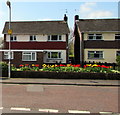
Tulips in The Alders, Llanyravon, Cwmbran
Yellow tulips and red tulips are alongside a garden wall in The Alders, viewed from Friars Garden.
Image: © Jaggery
Taken: 7 Apr 2017
0.05 miles
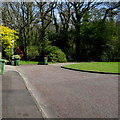
10
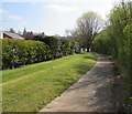
Path from The Alders to Llanfrechfa Way, Cwmbran
In the Llanyravon area in the southeast of Cwmbran.
Image: © Jaggery
Taken: 7 Apr 2017
0.05 miles